| |
| |
Pic de l'Orri s(u) The ski station Port Aine is a
well know road biking climb. The base of the ski
station is practically at 2000 meters. It is a
kind of island of a mountain - still far
away from the rugged main wall of the Pyrenees,
with realtively gentle slopes on all sides. With
a mountain bike (or even my touring bike with
35mm tires) you can get to the top of the
ski area and pick your way down, through the
plethera of good unpaved roads on the other
side, making this a loop over a two-way summit.
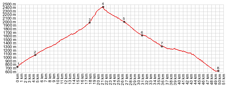
As you can see from the profile the workout to
get to Port Aine is a long steep climb. Even if it
is steep, the road seems to contour along the hill
to no end. The high snow covered peaks are very
far away. But I have a picture perfectly clear
day, and with a zoom lens they can be made to
appear in map like clarity. This is one day where
I have even clearer light than most all of the
pictures that people have shared on the web. At
the westernmost point of the road, a marked
trailhead shows a trail connection to La Baseta,
another MTB route, that is however much lower than
this one. The deep forested hills last till within a couple
of hundred meters below the ski area hotel.
Approching the top of the paved section, the road
crosses some elaborate drainage channels.
Surprisingly the luxurious hotel with ample
parking lots overlooking the mountain panorama is
a busy place. Not so much with people, even though
there are a couple of them doing spring
maintanance on the ski slopes. It's the animal
scene that is really happening here. The parking
lot is filled with heavy draft horses. I almost
cause a stampede with my bicycle. After the
initial excitement is over they pose for pictures.
Further up, the ski area is also used as pasture
for cows and llamas. I take plenty of picture of
this curious interdenominational zoo between the
mothballed ski lifts. All the creatures, including
myself, appear to be quite happy to be here. The objective can be clearly seen ahead, and it
really does not look that high. It's the
transmission tower on the relatively gently ski
mountain ahead. I pick my way up under the ski
lift and walk much of it, talking to the animals.
When it gets to steep I detour to the west, and
see that apparently there is a fairly good dirt
road that can be followed all the way from the ski
lodge on a western detour loop. The profile above
is an approximate reconstruction of my route below
the ski lifts. Approaching the top ridge the viewshed now also
includes the south side and its snowcapped walls,
receeding into the haze of the foothills and
flatlands. The top is a gently rounded knoll with
remnants of snowdrifts on this June day.
From South. (described
downwards). Even if my map material is a little
inconclusive. From the top the way down can be
pieced together. You can clearly see a good
unpaved road that follows a gentle ridge to the
west. All I have to do is walk and ride down to it
over a short, and not very steep ski slope. The
lower part of this is the area, that is
photographically the most interesting, because of
its many distinct "isles" of pine trees, dotting
the tundra. From the top further road cuts can be
seen below. A few minutes and several thousand degrees of
curvature later I am looking up at the
transmission facility far above on the perfectly
cone shaped mountain, providing a sense of
direction. As it turns out there is a whole
network of fairly good roads on this side of the
hills, and a gps is necessary to make sense of the
turns. Some intersections have signs, but the
destinations don't match anything on my map. I
only see one car back here, an adventurous looking
4 wheel drive camper of some sort. But he doesn't
stop to compare notes. With the help of my gps I
negotiate several cryptic intersections. My
original notes were more detailed. At point 6
stands a stone house and a regular parked car is
evidence, that the road is about to improve even
more. Eventually the wide roadbed of the Port de
Canto road shows up cutting through the green
hills not far below, cutting a monumental V into
the mountain side. The last part to get down to it is unexpectedly
rough. My day ride turns right here, to return
over paved Port de
Canto. But in order to show a strictly
increasing profile, and of course you could climb
the summit from this side too - I finished the
profile down the south side to Adral. The map
shows that there are several other options to meet
the Port de Canto road, either further up or down
its path.
A Dayride with this point as highest summit: PARTIALLY PAVED / UNPAVED ( < Collado de la Creu de Perves | Port de Bonaigua > ) Pic d'Orri s(u) , Port de Canto: Sort > Rialp > Port de Aine ski station > various paths and dirt roads with detours > Pic d'Orri s(u) > down various dirt roads > Port de Canto > Sort: r5:16.4,5 Notes: gps data and distances are on stolen computer |
||||||||||||||||||||||||||||||||||||||||||||||||


|
|
advertisement |
|
|
advertisement |