| |
| |
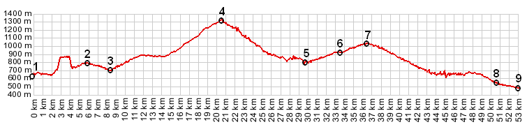
Route des Cretes s(u)
This summit is the
highest point on a ride around the Canyon of
Verdun, the largest Canyon in Europe. One can
still ride around the canyon and skip this
optional loop, but it would be a shame since it
has some of the best views.
From West. The profile covers the entire
northern side of a ride around the canyon. This
also includes Col
d'Ayen at point 7 and another small summit
between points 1 and 2. All of these are
substatantially lower than the highest point on
this route. The Route de Cretes is usually only
thought of as the section, starting at Point
Sublime, located several miles after point 3, and
ending at point 6. Right after the viewpoint labeled Point Sublime,
an equally sublime side road climbs back towards
the East. It takes in several astonishing
viewpoints and crests near the summit of this
forested hill. From East. (described
downwards). I think the best views are on
the upper portion of this side. The road follows
the edge of the canyon more closely. At times it
is possible to mistake the road on the other side
of the canyon for the one you are descending.
There is a small climb involved when the road
leaves the canyon edge to return further inland to
La Pallud. Here the Route des Cretes merges back
into Main Road, in Pallud-sur-Verdun, just
slightly west of where it took off.
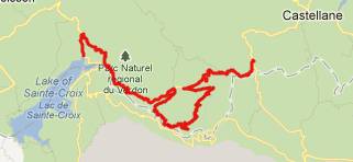
Dayride with this point as
the highest summit
Routes des Cretes , D71 Le petit St-Maimes s(u) , D71 Col d'Illoire s(u) , D71 Tunnel du Fayet s(u) :La Colle (1km west and 100m above Castellane) > Route du Cretes s(u) > Col d'Ayen(shp?) la-Pallud-sur-Verdun > Aiguines > col dI'lloire(shp) > D71 col d'Illoire s(u) > D71 Tunnel du Fayet s(u) > D71 Le Petit St-Maimes s(u) > Trigance > sp: 83.1miles with 9100ft of climbing in 7:48hours (VDO MC1.0 m4:12.5.19). The last summit point
with different start and end points on this Extended Tour
is: Col de Luens |
 Approaches
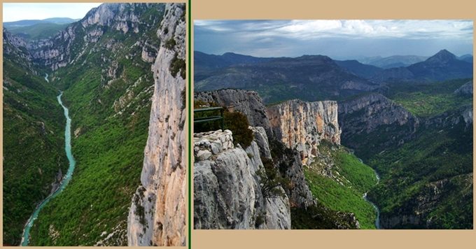
|
|
advertisement |
|
|
advertisement |