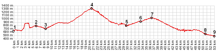
1.(00.0km,645m) START-END EAST: jct D6-D955 between
Castellane and Rougon
2.(05.8km,792m) profile turns left off D6 onto Route
des Cretes
3.(08.5km,690m) intermediate low point
4.(20.4km,1314m) TOP: Route des Cretes s(u)
5.(29.7km,767m) intermediate low point
6.(33.7km,923m) profile rejoins D6 in Pallud and turns
left
7.(36.2km,1032m) Col d'Ayen
8.(50.5km,523m) START-END WEST: profile turns left on
D957 towards Lac de Sainte Croix
9.(53.0km,472m) START-END WEST: north east end of Lac
de Sainte Croix, near D957