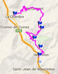
Col du Chaussy
The steep mountain walls around
St Jean Maurienne contain so many mountain passes,
made famous through bicycle races, that during a
week vacation you never get to anything else,
except the things "you just have to do". You know
... Col de
Madeleine, Col de Croix de
Fere, Glandon.
Galibier is
not so far away either. That the top of this pass
sees comparatively few cyclists, is not only a
shame, but also proof that the world needs longer
vacations. Col de Chaussy is one of the roads you
do not have to do. But once you've ridden it, you
might want to do it again. The reason is, that
there is little traffic, on a fairly wide, safe
road, great scenery and a good workout.
For me another reason to do it again is, that I
missed the most famous part the first time, an
optional short section of 18 serpentines over 4km
of very narrow road on the lower southern
approach. You could also look at this section as
part of a lower shoulder summit. The other side is
the route I took and included in the profile
below.
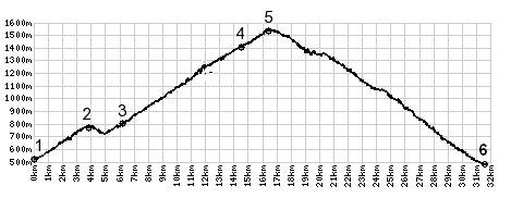 |
1.(520m,00.0km)START-END
SOUTH: D906, east of river l'Arc and St
Jean de Maurienne
2.(770m,03.7km)le Chatel
3.(780m,06.0km)Montvernier
4.(1400m,14.2km)Montpascal
5.(1532m,16.0km)TOP: Col du Chaussy
6.(520m,30.8km)START-END NORTH: la Chambre
|
 Approaches Approaches
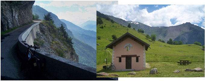
From East. Cycling along
the Arve river, west of St Jean, I see the sheer
limestone cliffs that reach above the road, in
waves and crests of stone turned sidewards.
Imagining a road that would climb these rocky
waves, my interest in this ride grows. There are
two ways to climb that first limestone step on
pavement. Profiled is the first chance to get off
the main road from St Jean. It is signed "Col de
Chaussy". A few short switchbacks negotiate
between thick walled houses under overhanging
roofs. The road climbs a gap, with the village Le
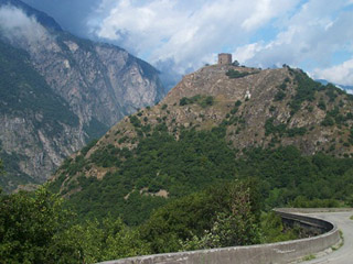
Chatel on the right and a old medieval looking
tower (Tour Berold de Saxe) on a knoll over the
valley of the Arve. This tower will come useful in
visualizing progress in the climbing progress.
In Montvernier this road meets the other option to
climb this first step, a road containing 18
serpentines in 4kms. The Montvernier Serpentine
Road leaves D1006 at an easily missed turnoff in
Pontamafray. This is the more famous lower
approach, even if it has fewer far views of the
peaks in the Belledonne Range. I missed it this
time around.
Continuing the description on the Hermillon
approach option. There are are several more groups
of large roofs reflecting in the sun, that testify
to human existence on a steep slope. The road
descends to the last of these humanoid habitats
between fountains and thick walls (Montvernier),
and then enters the meditational section of the
ride, a climb through green trees. At one point
the meditation is interrupted and the road goes
through an alcove hewn out of the natural stone
walls, with a sheer endless seeming dropoff on the
other side. It reminds me a little bit of the
shelf roads above Bourg d'Oisans, which are just
one mountain range away.
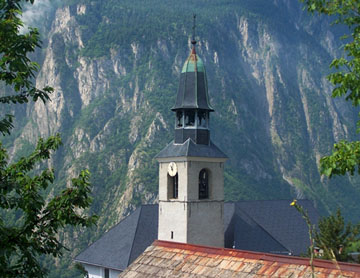
One more village speaks in ringing bells, with the
ornamented church tower above the small cluster of
houses. The arching sign "Mairie" is prominently
displayed above the biggest house in town. This
village, Montpascal, becomes foreground to the
distant high mountain scenery, and now the road
(which is quite a bit narrower here) just needs
four or five more switchbacks to where the trees
are getting scarce, but the views better, and the
summit is reached. On top is a picnic table next
to a chapel, and also a number of tables in front
of a closed restaurant.
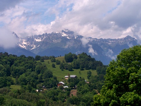
From West. (described
downwards) The bike rolls ever so slightly on a
straight road towards a nice, far view of the
mountains behind the Col de Madaleine
area. Then it descends into the trees. But now it
rolls much faster. The road quickly reaches the
turnoff to a narrow path in Bonvillard. From here
you can climb higher to an unpaved summit above
Col de Madaleine, going over Village de
Loop - Longchamp s(u). But the profile takes
the direct way down and continues over switchbacks
back to La Chambre in the valley of the Arve.
A Dayride with this point as intermediate
summit is on page: Village de
Loop - Longchamp s(u)
|
 |
|
|
|
 |
Historical Notes:
Medival Times: The "Tour Berold de Saxe" is
located before you reach Montvernier on the on the
Hermillon approach option, described above. This
small landmark tower dates back to at least 887AD.
That is the date, it is mentioned the first time
in writing. But the Romans probably did not
construct it. It was renovated by a certain
"Berold of Saxony" in the 11th century, and lay
abandoned by the 17th century. That was along time
ago, but it still managed to be of some importance
for much longer, 700 years. During WW2 the tower
was occupied by Germans.
Roads: The Montvernier Serpentine Road is
the much older option to reach Montvernier on
pavement. It took six years for the 4kms to come
into existence, between 1928 and 1934. The other
option, from Hermillon was not paved until 2012,
largely in response to cyclists, who now have a
great option to string several passes and summits
together in a day loop.
Cycling - Tour de France: In 2015 a climb
to this pass was included for the first time in
the Tour de France. Getting a peloton up the
Montvernier Serpentines is nearly impossible to
visualize. The route went up the Hermillon option,
starting in St Jean de Maurienne, ending at La
Toussiere: unbelievable 4500 meters of climbing on
a "almost-loop" with a one way climb at the end,
instead of connecting back to the starting point.
The other passes on this day ride were Col de Croix de
Fere, here only a shoulder point on the way
to Col du Glandon,
the Col du Mollard
and a one way climb to La Toussiere.

|