| |
|
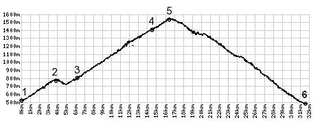
1.(520m,00.0km)START-END SOUTH: D906, east of river l'Arc
and St Jean de Maurienne
2.(770m,03.7km)le Chatel
3.(780m,06.0km)Montvernier
4.(1400m,14.2km)Montpascal
5.(1532m,16.0km)TOP: Col du Chaussy
6.(520m,30.8km)START-END NORTH: la Chambre