|
|||||||||||||||||
|
|
|||||||||||||||||
| |
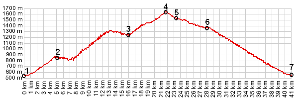
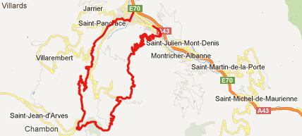
Col du Mollard
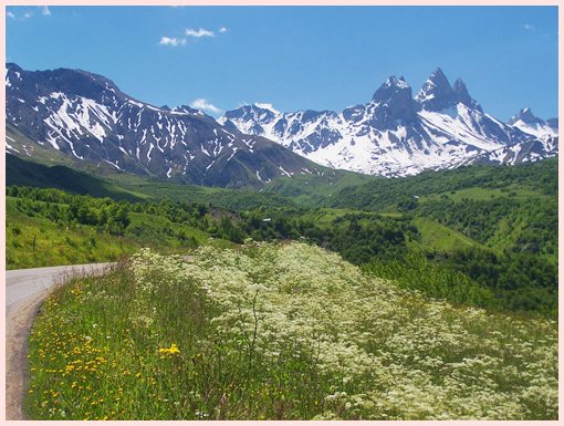
The best scenic view from the famous Col
de la Croix de Fere are the three glaciated horns of the
Aigles s'Arves, that prick the landscape like three shark
teeth. Well - this pass gets you one ridge closer to this
mountain jaw.
There are fewer bikes on this road than on the busy Croix de la Fere. But bicycles still seem to outnumber cars by a significant margin on a sunny day in June.
From West. I had a small problem trying to find the
turnoff to this pass, after descending from Col de la Croix de
Fere. The turnoff is several km west of St Jean d'Arves,
directly adjancent to a small power station dam, and it is
signed. The road starts to climb through forest and soon the first
view of the Aigles d'Arves appears ahead. The pass road winds in
switchbacks to the north, with ever improving views onto these 3
peaks, and also several other mountain groups. The top is the
town "le Mollard", located directly adjacent to the
summit, on this side. On top of the pass is a water fountain
dispensing drinking water, several pique-nique tables, some in
the open, some in shelter, and a riot of wild flowers in June.
From East. (described downwards): The viewshed in this
direction takes in the Maurienne Valley. The church in the first
village, Albiez le Vieux, is located on a small ridge, that
makes a perfect foreground for photos from many different
directions. Some of these are included in the picture page. In
this village the roads make some curious twists, maybe to slow
down motorists. There are two ways down from here. Rather than
rejoining D926 from Col de la Croix de Fere, the profile
descends to the south directly to Villargondran. Again the
mentioned church shows up in views, this time as foreground to
"les Grandes Rousses", a in June snow covered wall
also reaching over 3000m. The road descends in innumerable
switchbacks through the forest. A dayride with this
pass as intermediate summit is on the page: Col
de la Croix du Fere
The last summit ride with different start and end points on
this Extended Tour was: Col
du Glandon
back to Cycling
Passes in Europe
|
 Approaches