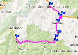
Col Du Galibier
In terms of numbers Col du
Galibier is the 9th highest paved pass road in the
alps. But that is only 113 meters below the
officially highest. To me the scenery "feels" the
highest here. During my ride cyclists outnumbered
cars by a large margin on this road.
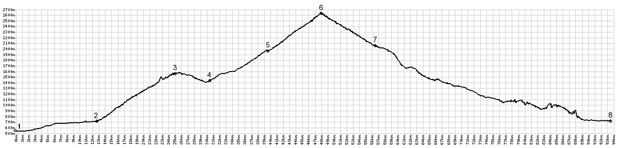 |
1.(550m,00.0km)START-END
NORTH ALT: Saint Jean de Maurienne
2.(720m,12.6km)START-END NORTH: profile
crosses l'Arc in Saint Michel de Maurienne
3.(1566m,24.7km)Col du Telegraphe
4.(1450m,30.2km)road crosses la Valoirette
in la Valoire
5.(1970m,39.3km)dirt road turnoff in Plan
Lachat
6.(2642m,47.5km)TOP: Col du Galibier
7.(2058m,55.8km)START-END SOUTH: Col du
Lautaret(shp)
8(720m,92.3km)START-END SOUTH: ALT: Bourg
d'Oisans |
 Approaches Approaches
From North. The profile starts way down
the valley in Saint Jean de Maurienne. The pass
road finally starts with a turnoff onto a bridge
over the river Arve in St Jean. It goes through St
Jean to St Michel and crosses Col de Telegraphe.
In comparison to this huge pass, Col de Telegraphe
feels like a shoulder point. But it does have more
than 500ft of approach height on the south side,
before the road starts climbing again to Cd
Galibier. And with the help you could descend much
further on the other side (according to the map
all the way into valley with the help of unpaved
roads)
In the ski town of Valloire the road makes a 90
degree turn to the right, in order to cut through
the center of the ski town, perpendicular to the
direction of the valley. All the businesses line
up side by side next to the road, with great views
down and up the valley. There are some curious,
uncharacteristic public pieces of art at some
intersections, that look like they could have been
carved by a chainsaw artist, who measures
proportions to the nearest length of a sawblade. I
saw no war memorials in this town, as are common
in less touristy small towns. Making another 90
degree left turn, the road now slowly extracts
itself from ski commercialism and stays at the
bottom of the valley, which is now getting ever
narrower.
The road and all the surrounding mountains are now
completely above treeline, and the mountains take
on a stark dry look. The brilliant sunshine next
to the road contrasts the icy peaks disappearing
into clouds of various shades of grey. The road
passes close to the daggar shapped peaks of the
Aiguilles d'Arvre. These peaks are the background
of the best views from Col de la Croix
de Fer and Col
du Mollard. But from here you never see
their jagged tops, and without a map the spot is
not recognizable. The hiking route to the refuge
below these summits starts from just south of
Valloire.
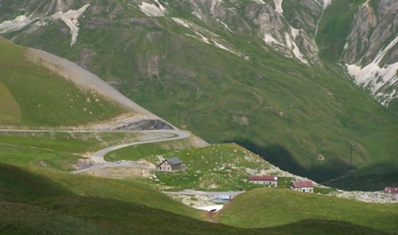
At Plan Lachat the road crosses the river and now
starts its switchbacks to climb the pass. A
dirtroad contnues the original aim of the paved
road in a straight direction. This wide track to
Col de Roches (2496m) must be on countless
pictures, taken by passing tourists. When you
start to climb the switchbacks, it is the one
motif that makes everybody with a camera stop.
Following the progress on my dimly lit GPS, it
looks like I am practically there at the summit.
But one look at reality and you see that it is 3
or 4km distance as the crow flies, but 10km of
road between here and the top. The summit ridge
resembles a giant bread loaf, compared to the comb
like ridges to the south. But this bread loaf
contains deep gashes with canyons.
Glancing above the handlebar, a summit restaurant
appears in view far above. It comes up (or I come
up to it) faster than expected. Surprise - this is
not the summit, but the entrance to a tunnel. 100
meters of climbing remain above the tunnel, which
is closed to bicycles, and who would want to use
it anyway ? At this point the last few switchbacks
are really nothing compared to what was already
cycled. But it feels like much more than nothing.
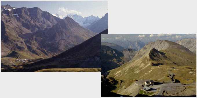
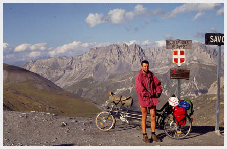
There are no structures at the top. But it still
appears to be a perpetually busy gathering ground
of people posing in front of the summit sign,
which also marks the boundary between the Savoi
Alps and the Haute Alps.
From South. (described downwards) At the
tunnel entrance on this side is a monument to
Henry Desgrange, who is thought of as the creator
of the Tour de France. The monument is easily
overlooked, because it is really a column with
writing on it, with few "monumental"
characteristics.
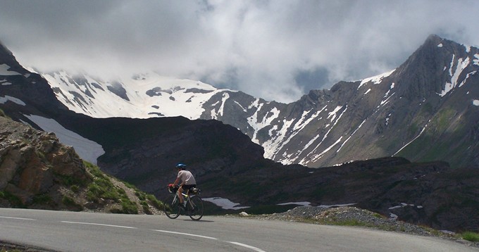
The best views of the landscape become apparent
after rolling down a few hundred meters from the
summit. It puts the exposed curves below the Pic
Blanc du Galibier (2954) in perspective. The
entire section down to the Col du Lautaret
lies in an alpine amphitheater above treeline.
History
The road was first built in 1880 with the
summit tunnel opening in 1891. The tunnel was used
for over 8 decades by all traffic, including the
Tour de France crossings. There was no highway
over the top. In 1976 the tunnel was closed
because of collapse danger, and the road was laid
over the top. The tunnel was reopened in 2002 as a
one way optional route for cars.
The south side of the pass road down to Col du
Lautaret was completely rebuilt in 1947, at the
same time that the snowsheds on Col du Lautaret
were installed. The new and old routes are
entirely separate and never meet.
Cycling: Col du Galibier was the first
pass crossed by any Tour de France. The year was
1911. A hundred years later the pass was part of
the race on two consecutive days. The race from
July21, 2011 ended on top of the mountain and was
won by Andy Schleck from Luxembourg. The following
day the pass was crossed from the north and ended
in Alp d'Huez.
The post WW2 tour de France (from
1947) crossed the pass 31 times (to 2011). The
1966 race was scheduled to include both the Col d'L'Iseran
and the Col du Galiber, in a 190km stage from Val
d'Isere to Sestriere. But due to bad weather the
stage was reduced to a 46km sprint.
On May 19th 2013 a stage of the Giro
d'Italia was scheduled to go up from the north
side and finish on top of the pass - that's about
two weeks before the pass generally opens. So it
does not come as a surprise that due to the snow
the race finished 4km below the summit on the Plan
de Lachat at the Pantani monument.
an earlier ride with Ralph on his recumbent with
much sunnier weather
Dayride with this point as highest summit:
COMPLETELY PAVED:
Col du Galibier x2 , Col de Telegraphe
x2: Saint Jean Maurienne <> St Michel
<> Col de Telegraphe <> Valloire
<> Col de Galibier <> turnaround point
300ft below summit (this is just a little bit
further than the tunnel portal): 62.8miles with
8220ft of climbing in 6:25hrs (VDO MC1.0
m4:14.6.25)
The last ride with different start and end
points on this tour is on the Col du Mont Cenis
page.

|