Scenic one-way climbs to ski
areas, favored by bicycle racers and Tour de
France aficionados alike, abound in the
Pyrenees. Here is another one. Considerable part
of it is above treelline, and there are great
views. Lots of bicycle touring companies make
their customers go up here. On top there is a
great little walk for those inclined, if the
weather plays along.
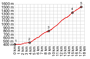
This road does give cyclists the sign treatment,
with remaining climbing elevation and grade.
However - when you get to the top of what they
call Hautacam, another sign indicates the
remaining climbing to be done to Kiosk Tramassel.
The Kiosk Tramassel is called Hautacam, as far as
this page is concerned. Just a little higher on a dirt track is also a
Col Tramassel. It has no road going down the other
side. It is however the starting point for a very
scenic short walk direction Pic de Narbou.
Dayride with this point as highest one way summit, and no two way summits: COMPLETELY PAVED: ( < Col de Tentes(ow) | Col d'Aubisque > ) Hautacam(ow) : Boo-Silhen > Hautacam << back down to Boo-Silhen with several miles of detour around the village: 22.8miles with 3990ft of climbing in 2:36hrs Notes: half day ride, started at 1pm. Day also included a short walk from the top to Col Tramassel and the knob before reaching Pic de Narbou h+b: max-min=5686-1335=4351, 26.7miles with 4823ft of climbing in 3:44hrs History Cycling - Tour de France: A stage of the race ended 5 times at the ski area parking lot, that is at a point below the highest point on the profile, between 1994 and 2014. The year 2000 was the longest of these days, with a roundabout 204km from nearby Lourdes. In 2014, the stage went over famous Col du Tourmalet (as well as a few other in comparison minor passes) and ended with a climb to this ski area, 145.5km. |