| |
| |
Mosquito Pass
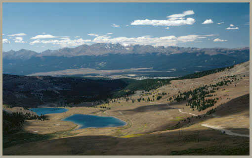
When approaching Leadville for
the first time, the Mosquito Range looks like a
long, straight comb. The vertical ribs of the
mountain range stand out like the teeth on a comb.
The view is impressive first of all, because of
the uninterrupted length of the range, apparently
without any breaks or saddles for roads.
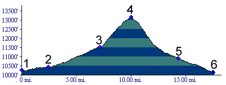
You wouldn't suspect that it contains the highest pass road in North America, and that it is still open today. One reason that this pass does not look as high as it really is, is that Leadville already lies at 10200 feet. It is really located on a shoulder of the same range. The valley bottom is half a thousand feet below Leadville to the west, and it lends more relief to the panorama of the Sawatch Range instead. Back on the east side, Mosquito Pass at 13186ft has acquired the infamy that comes along with the superlative of being the highest road, and that even though it was useful only for a very short time, and never really was profitable. It is also interesting to note that just a few miles to the south of Mosquito Pass, a pass of practically equal altitude crosses the range, Horseshoe Pass. Yet hardly anybody knows much about it, or uses it, mostly because the land surrounding it is controlled by mining interests. That crossing is said to have a road on the east side and today no established trail on the west side.
From West. 7th Ave in Leadville is
a convenient point to start a tour up Mosquito
Pass. From a topographic point of view, you are
already partly up the slopes of the Mosquito
Range. Instead you could start a few hundred feet
lower where the railroad used to discharge its
Leadville bound contingent, still called Leadville
Junction on maps. Going uphill, 7th Ave in Leadville becomes Evans
Gulch. The extremely smooth graded dirt road goes
past famous mining ruins, crosses the Mineral Belt
bike path and then continues its steady climb past
not quite as much mining destruction as in
adjacent California Gulch. This good road ends
abruptly without warning at the locked gates of
the "Diamond Mine". But looking closely, a remnant
of old, historic track manages to split off this
mining thoroughfare, and humbly crosses a gulch
through lots of rocks, in order to continue the
journey up the mountain range. The rocky track leads to a major junction at the
saddle with Prospect Mountain. Tracks lead up this
breadloaf shaped mountain, down the even rockier Birdseye
Gulch, and also continue uphill. Soon the
road switches back onto a steep, rocky climb that
can be seen from practically any vantage point in
the valley, as a straight uniform line cutting
across the ridge. Stumbling over the extreme
rockiness of this section, I couldn't help but
think: "Oh well, if it was only really heavily
used for a year, I guess they never got a chance
to improve the surface." With a final right turn
the road arrives at the high saddle. After being
overwhelmed with the view and regathering ones
senses, one notices a memorial stone to Father
Dyer, who carried the mail across the pass,
starting in 1864, often doing this at night so the
snowshoes would not break through. 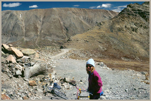 approaching summit of Mosquito Pass from American Flats From East. (also described upwards). A
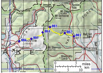
good all-weather dirt road, which historically
predates the pass road, runs from Alma to Park
City. From here the historic toll road followed
North Mosquito Creek around the north side of
London Mountain, while today's jeep road follows a
steeper course up South Mosquito Creek. Then
a steep climb goes to American Flats and the old
mining ruins of the town of Mosquito. The last
stretch from here to the summit over a shelf road
may be the most picturesque part of the road in my
opinion. This side is considered by many to be not
quite as rocky and steep as the west side.
History Colorado Gold Rush of 1859/60 (<Hoosier Pass|Weston Pass>): It was the second spring of the Colorado gold rush, 1860, and already some prospectors were ready to go to extraordinary heights in their search for gold. Amongst the many gold rush camp routes radiating out from South Park to the valleys of the Arkansas, the Blue River and beyond, was a route to the camp of Buckskin Joe and his followers. During this year they panned themselves way above the treeline, higher than any other prospector had done, up towards Mosquito Pass from the east side. One can only suppose that one day, one of them climbed the extra couple of miles to the top of the ridge and gazed down on what would be named California Gulch, into the valley of the Arkansas with the Collegiate Peaks behind it. A often told story survives from the period between the early Colorado Gold Rush and the Leadville Boom Period. One thing that helps keep it alive, is a memorial looking like a headstone on top of the the pass. Methodist preacher- prospector, John L. "father" Dyer crossed the pass the first time in the call to preach. Prior to August of 1861 he manned the altar of Mosquito town on the east side of the pass. Then he started to also take over the California Gulch mission on the west side of the pass. That was quite a crossing, on snowshoes in winter, alone at first. Then travelers wanted to join him. Apparently father Dyer was not averse to the physical challenge, because three years later he signed up to carry the winter mail over the pass, a distance of 37 miles. Hayden Survey: In 1873 Hayden's intrepid map makers, painters and explorers surveyed the area. When one of the results of this work was released, the atlas of Colorado, it showed Mosquito Pass as highest pass in North America, 13188 feet.
Leadville Boom (<Weston Pass|Hagerman Pass>): In October 8/1878 another story begins. The period when mail was carried over the pass by foot was irrevocably ended. On that date the Mosquito Pass Wagon Road Company was incorporated to build a road over the pass. The conditions that lead to this development can readily be deemed logical today. In 1878 Leadville was booming so loud it was deafening. The populaction in California Gulch (above today's Leadville) grew from a few hundred to 6000. In that year a telegraph line was also laid across the pass, which also helped winter travelers in not venturing off course. Another motivating factor in taking on construction costs for such a road was that the new section to be constructed was relatively short. There was already a fairly good road a long ways up the east side to the Mosquito gold camp, just a few miles below the summit. Also the distance savings for the traveler would be considerable. The arithmetic looked like this: From Fairplay to Leadville on the Mosquito Pass trail was 21 miles, 40 miles over Weston Pass, 72 miles over Trout Creek Pass. Mosquito Pass already was used to some degree, Weston was the most popular, Trout Creek the winter detour. Another route early Leadville miners used on rare occasions was a route 5 miles to the south over Horseshoe Pass, between Mount Sheridan and Horseshoe Mountain.- But then of course there was that pesky shelf road section on the west side. The new Wagon Road over the pass was already
opened in the spring of next year, 1879. From here
the story only becomes more quickly paced. As
short as father Dyer's story may be, the history
of the Wagon Road is even shorter. Owners were
pleased when 150 outfits a day crossed the pass
that first summer. They were also pleased when a
lack of snow allowed them to collect tolls into
mid December. They were not so pleased in February
of the next year, 1880, when the railroad crossed
Trout Creek Pass
to Buena Vista, a distance of only 35 miles from
Leadville. By August of the same year, two
railroads reached Leadville. The Mosquito Pass
road was closed in 1882, after owners had sunk 30
000 dollars into it. The road was formally
abandoned in 1910. Outside of its extraordinary height and natural surroundings, the reason for today's relative infamy of this road is an event, put on by the communities of Fairplay and Leadville. It has the catchy title "Get your Ass over the Pass", and the ass, being referred to is a donkey, or burro. It was first held in 1949 and is billed as the world championship burro race. Cycling: An early mountain biking guide, published in 1987 mentioned Mosquito Pass as being suitable for mountain biking in its appendix, without describing it any further (William L. Stoehr's: Bicycling the Backcountry).
|
 Approaches
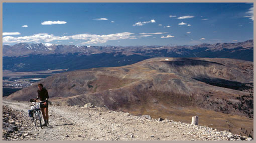
|
|
advertisement |
|
|
advertisement |