| |
|
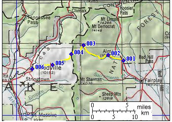
01.(10280ft,mile00) START-END EAST: Alma Junction on Co9 south of Alma
02.(10450ft,mile03) Park City; another approach from Alma joins from right
03.(11530ft,mile08) route deviates from Mosquito Creek by turning left
04.(13186ft,mile10) TOP: Mosquito Pass
05.(10930ft,mile15) profile continues left down Evans Gulch. But right down little Evans Gulch also serves as approach
06.(10150ft,mile18) START-END WEST: Leadville