| |
| |
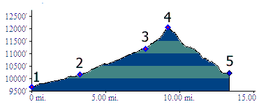
CR3 - Birdseye Gulch(sh) This shoulder summit is located
on the Mosquito
Pass approach from Leadville. The profile
combines that road with another way down. This
may be an attractive option, if exploring
Mosquito Pass as an out and back ride / hike,
but then opting for a change in scenery on the
way down. However this alternate route is quite
rough and rocky and requires a lot of walking.
Even though it feels like this shoulder summit
point is well down from Mosquito Pass, it is
still located at above 12000 feet.
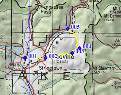
From South. The profile starts below
Leadville at the Arkansas River, between Leadville
and Turquoise Lake. 7th Ave west in Leadville
leads up Evans Gulch to Mosquito Pass and this
shoulder summit. You can also pick up Evans Gulch
(also called CR3) from the Mineral Belt bike
path. There is no sign, but the "exit" is at
the Matchless Mine, at an easily recognizable spot
where the path crosses a paved road on an
elaborate bridge. Evans Gulch soon becomes a wide,
steadily climbing dirt road, all the way to the
Diamond Mine. Here the road seems to just lead
into the mine, while the poor, little neglected
county road has to swerve to the left and cross a
gulch. The route from here on is very rocky, the
kind that are part of the pavement, not the kind
that roll about. Still a long portion is rideable,
until it becomes really to steep, approaching the
shoulder summit. At this point five tracks
converge. The first three are obvious, the fourth
is a steep track up Prospect Mountain to the east
(not shown on any maps that I have seen) and the
fifth one is a short cut coming down from a a
switchback of the Mosquito
Pass Road.
From North. (described downwards) The way down starts out steep and rocky, and it gets worse more often than it ever gets better, or to put it less obtusely, it just gets worse. Even in the end of August, the double track crosses wet and muddy sections, and the lower part contains several stream crossings. To the right the adjacent mighty wall of the Mosquito Range seems to dwarf the rest of the scenery more and more. Many years ago, when I rode this route the first time, several car wrecks were permanently stuck along this route. They have since been removed (I wonder how). When you cross the railroad tracks of the Leadville tourist train, you are close to the pavement. As the gulch approaches the pavement it takes one more detour to the north. Approaching this point from the other direction,
the turnoff has no signs and is difficult to find.
It is located about 5.5 miles past the junction of
the roads to Tennesee
Pass and Fremont
Pass, just past a single house on the right
and where the powerline crosses the road.
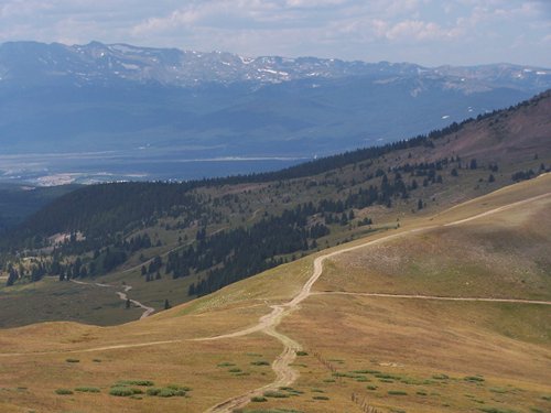
Picture Locations: top:
leaving Leadville on 7th Ave., Evans Gulch bound,
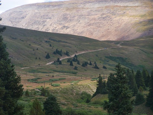
middle: road leading up to shoulder summit with Mosquito Pass road
visible on background ridge. bottom: Evans Gulch
is towards back left, Birdseye Gulch is the
straight line leaving towards the right.
Dayrides. PARTIALLY PAVED / UNPAVED / DOUBLE TRACK HIKE AND BIKECR3-Birdseye Gulch(sh): jct: southern access Rd to Turquoise Lake - Arkansas River Crossing > Leadville <> out and back towards Fremont Pass, fruitlessly looking for the access route up Birdseye Gulch [this is about 16 miles of the total] >> up Evans Gulch > CR3-Birdseye Gulch(sh) <> out and back to the top of Mosquito Pass >> down Birdseye Gulch > Co 91 south > Leadville > back to starting point: 41.1miles with 3880ft of climbing in 5:08hours (VDO MC1.0 m3:11.8.31 t11_6). Notes: A planned bike and hike to the top of Mosquito Peak was scrapped because of a weather conditions. |
 Approaches
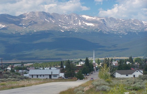
|
|
advertisement |
|
|
advertisement |