| |
| |
Canyon Creek Trail s(u)
Here is one more reason for mountain
bikers to torture themselves to ascent the rocky
Tomichi Creek Rd. It is not just Tomichi Pass
anymore. A single track leaves the Tomichi Pass
Road before reaching the top, and leads up the
ridge to the south. It goes higher than any of the
mining road passes in the area. On the other side
of all that walking waits a monumentally long
downhill, all on single track.
With the top of the pass well in sight, a trail
sign, some distance from the road shows the start
of Canyon Ridge Trail. The next portion of the
trip does not get any easier. The bike has to be
pushed, heaved, maybe carried, occasionally ridden
by those who think it's worth it for a couple of
yards. But this is also the scenically most
exciting part of the trip. Tomichi Pass, Hancock Pass, Williams Pass, and
other side spurs to mines can all be seen, like
lines on a map from above.The top of the trail is
also the top of Granite Mountain 12598ft.
From West. (described
downwards). The trail follows along the ridge line
of this rounded mountain, and then traverses along
a giant bowl of Tundra. At the end of the traverse
there are two trail junctions in close proximity.
One climbs a little and then also descends to the
Tomichi Creek Rd, while the option shown here
continues west. The signed Canyon Creek Trail crosses a secondary
ridge, that joins the main ridge at about the same
elevation, and traverses along another big bowl
down to treeline. But there are many more miles of
single track left. The trail seems to be well
used, judging from all the tire tracks and the
rideability. After about 5 miles, there is a junction with a
road. But the road climbs away from the creek,
while the trail continues to follow it. Another
trail junction after 3 miles allows access over
more trails to points north.
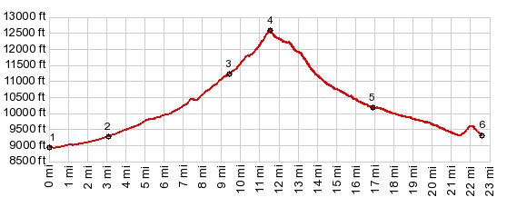
Dayride with this point as highest summit: PARTIALLY UNPAVED / SINGLE TRACK (< Monarch Pass | Black Sage Pass > ) Canyon Creek Trail s(u) : a short distance up the western start of Old Monarch Pass Rd > down Old Monarch Pass Rd > up Tomchi Creek Rd north > White Pine > Tomichi > up Canyon Creek Trail > Canyon Creek Trail s(u) > down Canyon Creek Trail > Tomichi Creek Rd south > back to starting point: 29.8miles with 4810ft of climbing in 7:04hrs (garmin etrex30 m5:18.6.12). Notes: that wasn't the route I had planned. But after having given up on the Tomichi Pass, Waunita Pass, Black Sage Pass loop, because of all those rocks, I met two mountain bikers going up, who told me about this route. |
|
|
advertisement |
|
|
advertisement |