| |
| |
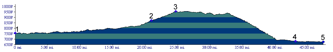
Rabbit Ears Pass
Rabbit Ears Pass is named after a
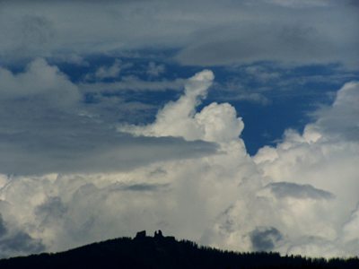
rock formation above its summit, resembling - you
guessed it - rabbit ears. They can be spotted on
the horizon from as far as Kremmling to the north,
and Walden to the east. This fact also gives a
clue to the surrounding landscape. Other examples
of volcanic outcrops like this can be found in the
surrounding hills, if you look for them. Still -
the "rabbit ears" stand out like two sore thumbs
in a landscape of gentle forested hills. They make
a superb orientation landmark from three
directions. In contrast - say in southern Utah for
example - you would be looking at an entire rabbit
colony, and rocks like this don't get the
privilege to serve as landmarks. The rabbit ears
on this pass however are remnants of a volcanic
flow in the form of Basalt and also a volcanic
outburst that left a layer of angular rocks
fragmented together (known as Breccia). The rabbit
ear colonies of southern Utah are in majority
eroded sandstones.
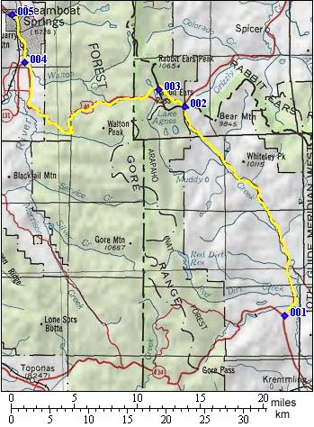
From West. Leaving Steamboat
Springs, a shady bike path follows the Yampa River
out of town. On a hot day in June it may be hard
to trade the shade and comforting sound of nearby
flowing water to the shoulder of a four lane road,
however spacious it may be. But during cool weather this is a great workout,
with not much to distract you from getting as much
out of yourself as possible. So maybe the lack of
scenic distractions can be beneficial to the
workout ( -maybe for some people). All it is - a
single ramp with a few curves working its way up
the breadloaf shaped northern end of the Gore
Range. As the road gains elevation, Lake Catamount
below and the regularly curving roads around it,
take on a geometric design of their own. Finally enveloped in high forest, the road passes
the "West Summit", but after a negligible drop,
keeps climbing anyway. The highest point is
reached shortly after the unsigned turnoff to "Old Rabbit
Ears Pass". From East. (also described upwards) The
Rabbit Ears pass road leaves from the top of Muddy
Pass, an even lower continental divide crossing.
The route shown on the profile includes the
southern approach of Muddy Pass, which is the the
route I followed in the three day tour below.
Crossing the two low passes this way, one only
spends about three miles east of the continental
divide. That is the section between Muddy Pass and
Rabbit Ears Pass and it is a single climb. Rabbit
Ears Pass is marked with a sign and elevation. But
the road keeps on climbing. At a jct with FR100, a forest road stays at above
8700ft to connect with the Gore Pass Road near its
summit. In the opposite direction the Muddy Creek
Trailhead provides a short connection to Old Rabbit
Ears Pass on foot or with a mountain bike.
Continuing on the paved road, a few large radius
bends and ever so slightly rolling hills reach the
unmarked highest point.
A Dayride with this point as intermediate
summit is on page: Old Rabbit
Ears Pass Three Day Road Tour: A supported camping
tour, done by the Denver Bicycle Touring Club in
past decades, went like this: Day 1: Steamboat
Springs to a campsite on top of Gore Pass, 50
miles measured distance. Day 2: Gore Pass to
a campsite near Granby, 52 miles. Day 3: Granby
over Willow Creek Pass, then over Muddy Pass as
shoulder point leading to Rabbit Ears Pass, and
back to Steamboat Springs, 90 miles. All mileages
were measured with a now antique, Schwinn
approved, pinwheel driven odometer, guaranteed to
be accurate to within aproximately 15 percent,
when not going too fast for a misfunction to occur
(r1:83.09.03).
One Week (very) large Group Ride (<Monarch Pass | Poncha Pass>):
The pass has been on "Ride the Rockies" during
90 93 95 98 01 and 04. The stage has been
Steamboat Springs to Granby or reverse, and once a
long 98 miles between Steamboat Springs and
Frisco. ( Statistics compiled up to 2005 ). History Hayden Survey: The Rabbit Ears Pass area
was visited by the Hayden Survey in their mammoth
project to map the American west in 1876. The
first primitive road following prospector trails
over the pass was also built in that year.
Modern Highways (<Berthoud Pass|Red Mountain Pass>):
Following WW1 a frantic road building program got
under way in the US. Road builders now tried to
adhere to a standard of a 6 percent grade - I am
sure some would say less than really interesting
climbing workout on a bicycle. Modern long roads
were still few and far in between - enough so that
they were given names, that people actually
remembered. Colorado's Victory Highway crossed Berthoud Pass and
Rabbit Ears Pass on its way between Denver and
Salt Lake City. Between 1957 and 1859 the road was
paved and relocated from the Old Rabbit Ears Pass
road to the current route.
|
||||||||||||||||||||||||||||||||||||||||||||||||
 Approaches
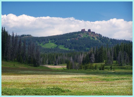
 A later modified motel version of
this DBTC tour went as follows: Day 1: Kremmling
> Rabbit Ears Pass > Steamboat. Day 2: a
dayride to the Hahn's Peak area and returning to
Steamboat. Day 3: Steamboat Springs > Gore Pass
> Kremmling. The distances measured 62, 78 and
79 miles (m1:88.09.03-05).
A later modified motel version of
this DBTC tour went as follows: Day 1: Kremmling
> Rabbit Ears Pass > Steamboat. Day 2: a
dayride to the Hahn's Peak area and returning to
Steamboat. Day 3: Steamboat Springs > Gore Pass
> Kremmling. The distances measured 62, 78 and
79 miles (m1:88.09.03-05).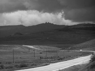 Railroads: A route over
Rabbit Ears Pass was surveyed for Moffat's Denver
Salt Lake and Pacific railroad. But instead the
route was finally laid below
Railroads: A route over
Rabbit Ears Pass was surveyed for Moffat's Denver
Salt Lake and Pacific railroad. But instead the
route was finally laid below |
|
advertisement |
|
|
advertisement |