| |
| |
Gore Pass When you say "Gore Range", the
image that often comes to most minds is one of
vertical peaks, lower than 14000 feet, but more
rugged than many that high. The reason is
because most people see the Gore Range as they
emerge from the west side of Eisenhower
Tunnel, or if cycling, from the top of Loveland Pass.
But there is also a Gore Pass through the range
of the same name, more than 30 miles to the
north, and it presents a very different picture.
This is not really the pass with spectacular scenery. Instead it's an area for those who like to be alone in the forest - by themselves or in company. This area will never run out of comfortable camping spots in the woods, unless the woods disappear.
From East. Gore Pass rises out of the
sagey highlands of Middle Park into a cool pine
forest, or at least that's what it used to be
before the pine beetle got a hold of it. There are
no interesting views along the way on this side,
except maybe for the sign advertising cowboy boots
ranging from 39.99 dollars to 799 dollars for sale
at the FM Light store. A few houses along the way
make a deserted impression. The road on top of the pass resembles an arrow
through the forest. There is a pass sign, and
opposite that in between two piles of pine beetle
kill, a stone with a plaque, mentioning the gastly
deeds of Mr Gore the Irish game hunter for whom
this pass and range are named, and Jim Bridger wh
o guided him From West. (described downwards). I like this side better. But maybe that's because during my last ride over this pass it was very hot, and this was the way down. Also, while the bike rolls along on its own, there are two quick, reminding far views of high peaks to the north. After a few hundred feet descend, the road levels out and traverses a long high park area. A place like this can even make a tree killed by pine beetles look picturesque (picture below). From here a spectacular descend on FR212 into Gore Canyon on a dirt road (which is part of the Great Divide Bicycle Route) is possible. The Gore Pass Road has one more climb that is
definitely noticable, It has enough climbing on
both sides that I count it as a separate summit.
But it too stays in the forest. Descending into
Tonopas, the forest turns into a sage landscape.
Turning back during a late June afternoon may
present a cloudscape above the mountains that are
left behind, that is as spectacular as many
mountain skylines. This may feel like the end of the pass ride, but
looking at the profile, the majority of the
descend is actually still ahead when turning left
at Tonopas (no services available here) and riding
on to Bond (ditto about the services) towards the
Colorado River and State Bridge (There may be some
services here if there is a rock concert going on,
but I wouldn't count on it). This stretch also has
another small climb with a great far view west to
the Flattops. Turning right in Toponas instead
also descends from this high sage plateau, but not
nearly as much. 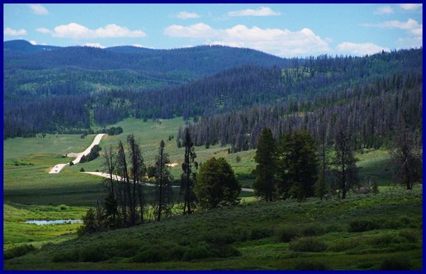
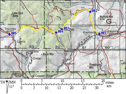
Dayride with this point as highest summit PARTIALLY PAVED / UNPAVED: Gore Pass , Trough
Road Pass : 381rd north of Green Mtn
Reservoir > Co9 north > CR1 west > Trough
Road Pass > Radium > up FR111 > FR212
Radium - Toponas(shp) > Co134 east > Gore
Pass > Kremmling > Co9 south > back to
starting point on 381rd: 51.8miles with 5160ft of
climbing in 4.62dec_hrs (Avocet50 or Cateye:
m2:98.9.20) A day on a Three Day Tour with this point as
highest summit Three Day Road Tour. A supported camping
tour, done by the Denver Bicycle Touring Club in
past decades, went like this: Day 1: Steamboat
Springs to a campsite on top of Gore Pass, 50
miles measured distance. Day 2: Gore Pass to
a campsite near Granby, 52 miles. Day 3: Granby
over Willow Creek Pass, a shoulder of Muddy Pass
leading to Rabbit Ears Pass back to Steamboat
Springs, 90 miles. All mileages were measured with
a now antique, Schwinn approved, pinwheel driven
odometer, guaranteed to be accurate to within
aproximately 15 percent, when not going too fast
for a misfunction to occur (r1:83.09.03). A later modified motel version of this DBTC tour
went as follows: Day 1: Kremmling > Rabbit Ears
Pass > Steamboat. Day 2: a dayride to the
Hahn's Peak area and returning to Steamboat. Day
3: Steamboat Springs > Gore Pass >
Kremmling. The distances measured 62, 78 and 79
miles (m1:88.09.03-05)
Gore Pass has been a essential crossing on the
route west to Salt Lake City, since these routes
have been pioneered. The more difficult part of
this passage were the passes over the front range,
and those changed between Berthoud Pass and
Rollins Pass. The Civil War Years (<Berthoud Pass | Yellowjacket
Pass>) : A number of passes in Colorado
received attention because of the impending civil
war in 1861. Fear of isolation as well as business
reasons drove Edward Berthoud and Jim Bridger to
explore a route suitable for stage traffic between
Denver and Salt Lake City. Berhoud was
participating in this as a supporter of Denver
business interestes and Jim Bridger was pulled out
of retirement by the COC, the Central Overland and
California Pikes Peak Express Company. After Berthoud discovered today's Berthoud Pass, Jim Bridger wholeheartedly endorsed the idea of using it for a stage route to Salt Lake. The mining engineer Berthoud and the legendary trailfinder Bridger spent a summer riding old Indian trails to come up with the rest of the proposed route. From Berthoud Pass the route entered middle Park. It left middle park over Gore Pass, then followed US40 to today's Craig From there it went south over Yellowjacket Pass (parallel to the Co13 Nine Mile Gap Summit) to Meeker, from where Route64 leads to Salt Lake City. However, in the end nothing became of the planned
stage route. It did abandon the Indian attack
plagued South Pass route. Resources to handle such
difficulties were withdrawn for the impending
hostilities with the south. But rater than run the
new mail and stage route through Colorado, it only
was shifted to south as far as Bridger Pass in
Wyoming. Historic Touristic Routes (<Rollins Pass):
But in 1861 some mail was carried over Gore Pass
en route from the Missouri to California. But it
took till 1865 till another Denver promoter, Bela
M Hughes surveyed a route from Salt Lake City to
Denver over Gore Pass. Again the main problem of
the project was not Gore Pass but Berthoud Pass.
Faced with great difficulties of getting their
wagons up Frazier Creek towards Berthoud Pass,
they instead pioneered a new route over Boulder
Pass, also know as Rollins Pass. Instead it took
till 1874 till the exisiting trail over Gore Pass
was turned itn an improved wagon road.. A road
over Rollins (Boulder) Pass, connecting to Denver,
was already a year in existence. Now no more high
mountain passes stood in the way of a new stage
road between Denver and Salt Lake City. The road
was first opened in 1865 and in 1867 it became a
toll road. In 1872 a piioneer built a house on
top. Railroads: No railroad ever crossed Gore
Pass. But it would have been feasible, if parts of
Wyoming were not so darn flat. In 1880 the Denver
Utah and Pacific Railroad proposed a narrow gauge
railway over the top, and in 1881 the Denver Rio
Grand also surveyed the pass. But nothing became
of it.
Compared to that story, Henry Gannett's
explanation, that the pass is named after a Denver
Goldsmith can barely compete, even if it is by
some as highly respectable, as a member of the
Hayden Survey. And then there is the description
"gore" which can also apply to the wedge shaped
landform of Gore Canyon. Cycling-Ride the Rockies: (<North La Veta Pass|Hoosier Pass>): Between 1986 and 2005 the pass saw the riders of the Denver Post's "Ride the Rockies" only once during 04 on a stage between Granby and Steamboat Springs.
|
||||||||||||||||||||||||||||||||||||||||||||||||

 Approaches
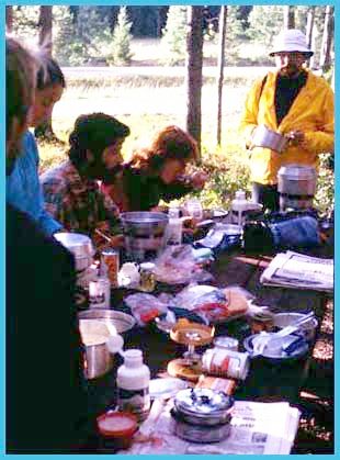 History
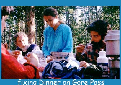 The Name: At times it was
also called Elkhorn Pass, and where the name
"Gore" came originally came from is disputed. But
one story is so colorful that the others pale in
comparison, and that's the one that lives in the
mind of tourists. Today the name Gore stands for
the hunting exploits of an Irish man, who probably
only saw the high peaks of the Gore Range from a
distance. He showed up in Fort Laramie in 1853 and
killed as much game as humanly possible in
Colorado as far north as Muddy Pass, and maybe
some distance north of that till the winter of
1854/55. Game in Wyoming and Montana east of the
Big Horn Mountains also were not safe from his
exploits. Marshall Sprague in his book "the great
Gates" tells how, at the end of his "hunting
season" he agreed to sell his equipment (at one
time including twenty one carts of champagne, six
wagons plus fourteen dogs and 114 horses) to the
American Fur Company, but then burned it all in a
fit of temper over the price.
The Name: At times it was
also called Elkhorn Pass, and where the name
"Gore" came originally came from is disputed. But
one story is so colorful that the others pale in
comparison, and that's the one that lives in the
mind of tourists. Today the name Gore stands for
the hunting exploits of an Irish man, who probably
only saw the high peaks of the Gore Range from a
distance. He showed up in Fort Laramie in 1853 and
killed as much game as humanly possible in
Colorado as far north as Muddy Pass, and maybe
some distance north of that till the winter of
1854/55. Game in Wyoming and Montana east of the
Big Horn Mountains also were not safe from his
exploits. Marshall Sprague in his book "the great
Gates" tells how, at the end of his "hunting
season" he agreed to sell his equipment (at one
time including twenty one carts of champagne, six
wagons plus fourteen dogs and 114 horses) to the
American Fur Company, but then burned it all in a
fit of temper over the price.|
|
advertisement |
|
|
advertisement |