| |
|
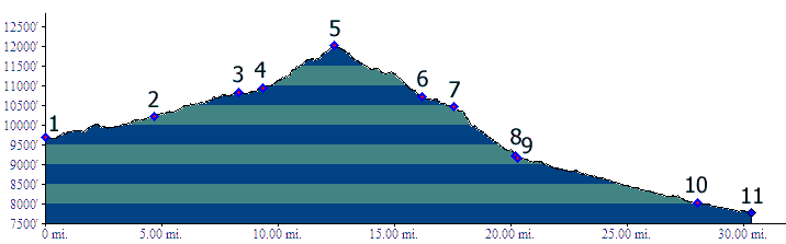
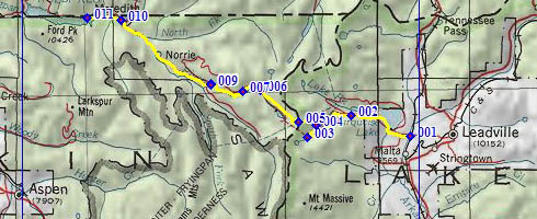
01.(9680ft,mile00) START-END EAST: southern Turquoise Lake access road crosses CR9c and old railroad tracks, west of Leadville
02.(10230ft,mile05) START-END EAST ALT: profile stays left, changing onto FR105 to Hagerman Pass
03.(10830ft,mile09) parking lot at Ivanhoe-Bush Carlton tunnel, eatern portal
04.(10960ft,mile10) Hagerman Pass Rd diverges from old railroad bed. The trailhead to Hagerman Tunnel eastern portal is a little before this.
05.(12010ft,mile13) TOP: point of highest elevation, Hagerman Pass is located a short distance past this at altitude 11925
06.(10713ft,mile17) Ivanhoe Lake road joins route from hard right
07.(10470ft,mile18) START-END WEST ALT: scenic park area of Ivanhoe Creek and western junction with forest road to Sellar Lake
08.(9220ft,mile21) eastern junction with forest road to Sellar Lake
09.(9160ft,mile21) juction with forest road to Fryingpan Lakes trailhead, and beginning of pavement
10.(8030ft,mile28) Thomasville
11.(7780ft,mile31) START-END WEST: road crosses Fryingpan River, on west side of Ruedi Reservoir, just east of Meredith