| |
| |
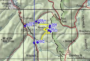
FR751 Ptarmingan Hill(sh)
The Gore Range south of Vail Pass hardly
resembles the range of the same name north of the
pass. On the north side a a high rock wall is
protected as a wilderness area. On the south side,
stretching to the Tennessee
Pass road, all sorts of travelers from
mountain sheep to passenger cars, pass through the
area on a fairly dense network of trails, among
them also mountain bikers. This is one of the more
obscure loops in the area. It connects the western
approaches of Ptarmigan
Pass with the western approach to Shrine Pass. In order
to traverse the profile in its entirety, a short
portage is required.
From South. FR702 Resolution Creek Road leaves from the south east corner of Camp Hale. It is signed at the junction with FR708 Mc Allister Gulch. FR702 climbs steadily only with slight wave like turns towards the treeline. At one point, where the steepness increases just a bit, a look back yields a great view of the cross on Mt Holy Cross. During late summer, when all the snow has melted except for the cross in the coloirs, one can almost imagine the religiosity that drove people to name the peak back in the 1800s. Shortly before the summit of Ptarmigan Pass, and
just after the road has finally climbed entirely
above treeline, FR751 diverts from the Resolution
Creek Road and switches back to the west. The next
short segment is supremely scenic as the road
traverses the high alpine tundra, situated at a
perfect vantage point onto the entire Holy Cross
Range. The road passes between Ptarmigan Hill on
the right (12143ft) and Resolution Mountain on the
left (11905ft), both shaped like aunt hills. Even
those oblivious to the scenic splendor across the
valley should still enjoy this stretch, as riding
becomes much easier. The road levels out and
eventually imperceptivity rolls over the high
point.
From North. (described downwards). Shortly past the summit FR751A diverts towards the west, direction Mc Allister Hut. That option is part of the FR708 Resolution Mountain s(u) route. This route continues on FR751 downhill on the other side of a "closed" barrier, referring to motor vehicles. Several switchbacks descend uniformly on a densely forested slope without views. Several lesser used roads branch off towards the left. The description follows the most heavily used branch at every intersection. The road takes on a more abandoned character until it finally ends, still a small distance above the valley floor. A short portage can be used to connect to the FR747 Wearyman Gulch Trail/Road. But it does go through a wet area, that was even still a bit muddy at the end of August 2011. The route is marked with blue trapezoids as a snowmobile route and leads through a timber cut area. It leaves the end of the road by turning 90 degrees to the left, then skirts around a small creek, then climbs a short distance to FR747. There is no indication on FR747 of this turnoff. One landmark is a powerline close to the northern edge of the subalpine meadow where the routes merge. The upper part of FR747 Wearyman Gulch is fun to ride, fairly smooth and very steep in places. The lower part can be more problematic. Wearyman Road has such a strong attraction on Wearyman Creek, so that it not only crosses it several times but just plain follows it at times. The name Wearyman Road Creek may be more appropriate than Wearyman Creek Road. One Corollary to Murphy's Law says, that if you are going to meet a 14 ATV convoy anywhere along the route, you will meet it in the creek. Shortly after Wearyman Creek/Road
merges with FR708 Mc Allister Gulch Rd (see
beginning of western approach), the route also
joins the Shrine Pass
Road. From here its a fast roll down to Redcliff,
a town which serves as antidote to nearby Vail. It
is decay at its most pleasing. The profile
continues along the lower Redcliff access road to
its lowest point, where it crosses under Co24 near
its low point between Battle Hill Summit
and Tennessee Pass. |
 Approaches
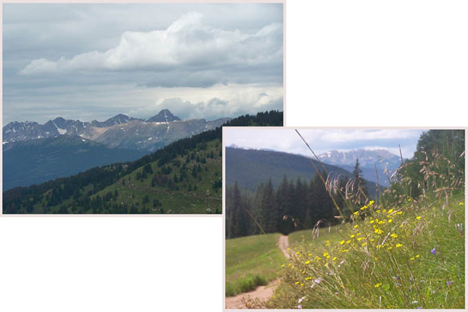
|
|
advertisement |
|
|
advertisement |