| |
|
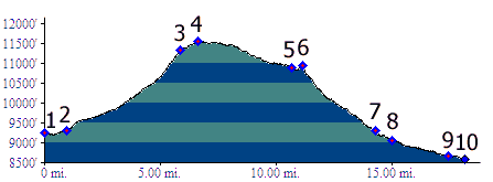
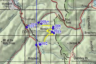
01.(9240ft,mile00) START-END SOUTH: northern access road to Camp Hale
02.(9320ft,mile01) jct with FR708 Mc Allister Gulch. Profile stays right on FR702 Resolution Creek
03.(11350ft,mile06) turn hard left onto FR751
04.(11540ft,mile07) TOP
05.(10900ft,mile11) begin portage on snowmobile route
06.(10940ft,mile12) end portage and turn down FR747 Wearyman Gulch
07.(9290ft,mile15) FR708 Mc Allister Gulch joins from right
08.(9050ft,mile14) route turns left down Shrine Pass Rd
09.(8670ft,mile18) Redcliff
10.(8580ft,mile19) START-END NORTH: lowest poit on Redcliff access road, below Co24 Bridge