| |
| |
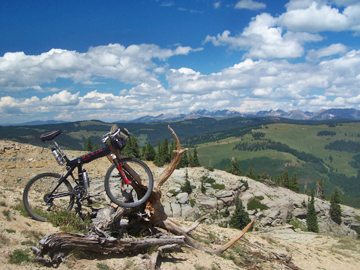
FR708 Resolution Mountain
s(u)
The Gore Range between Vail Pass and Tennessee Pass has
many great bikable passes and summits. Even more
impressive panorama points can be reached if one
is willing to walk the bike just a bit. But what
do I know ? Maybe other people ride this sort of
stuff. Anyway, traversing the top of Resolution
Mountain requires walking only a very short
section without trails. I nominate this summit as
the best mountain panorama, at least between Vail
and Leadville. It covers 360 degrees from
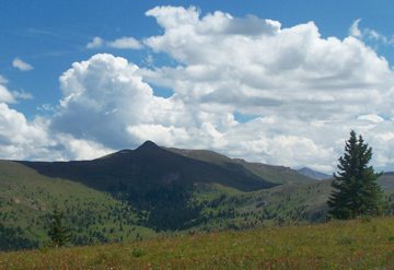
Tennessee Pass, Mount Holy Cross and the Sawatch
Range, south to the peaks in the Gore Range
wilderness. Compared with that part of the Gore
Range, the range by the same name east of here has
a more subdued character with its many other
bikable summits. Resolution Mountain is also a
favorite cross country skiing peak, partly due to
the presence of an alpine hut, belonging to the
10th mountain division hut system.
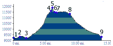
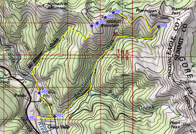
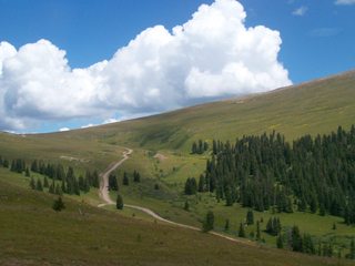
From West-1. The road up Mc Allister Gulch can be seen from Co24 for quite a distance south of Camp Hale. But it is on the other side of South Fork Creek. To get there, it makes sense to take the northern entrance to Camp Hale, and then head for its south east corner. Soon a sign makes you choose between FR708 Mc Allister Gulch and FR702 Resolution Creek. The profiled route ascends the former and descends the latter. Traversing along the valley the road already gains considerable elevation, so that the peaks of the Sawatch Range become visible. Best to enjoy the view now - the next time I saw them, I was quite a bit more tired. The point before the road enters the gulch is also a prime vantage point onto Camp Hale. When railroads were still crossing Tennessee Pass, this must have been the prime vantage point for railroad photos, in which the landscape played as important a role as the rolling stock itself. My first impression of this road was: this road
is steep but not too steep, a little rocky but not
too rocky. But first impressions are generally
only partially correct. As a whole, there are
really no rocks to speak of, and the steepness
wears, slowly but surely. I rode much of the first
couple of miles. After that I was content to walk.
When the road finally does break out into a
clearing, it first presents views of the green
depths of the Tennessee Pass road, and another
thread like road, climbing the rounded hills
across to Kokomo Pass. A hundred feet higher and
the northern Gore Range centered around Mount Holy
Cross appears in perfect morning light. The meadow
reaches to treeline. From here a track goes
straight up to the right, up Resolution Mountain.
The continuation of the main track, FR708, can
also be seen (and cycled/walked), continuing on
the ridge to the north. Turning back to the track
up Resolution Mountain: it's a tough slog, but
very short. It makes good training if Imogene Pass is
something you would like to do.
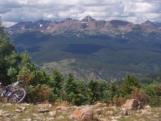
From West-2. Looking
down the eastern side of the peak, you can see the
Fowler-Hilliard Hut. Descending to it covers
roughly the same elevation difference, as the
short hike up Resolution Mountain. The walk down
is uncomplicated and only takes a few minutes.
From there a flat access road reaches across to
join with FR751. Both directions of FR751 are
viable return routes. But by far the more
attractive one is the one described here,
continuing to the right. A traverse across the
tundra puts the Sawatch Range in ever changing
relationship to the road just traversed,
surrounded by mountain meadow hills on all sides.
This road soon merges onto FR702, not far below Ptarmigan Pass.
The roll down back down to where we started is
very quick.
Dayrides with this point as highest summit
point PARTIALLY PAVED / UNPAVED / BIKE AND HIKE WITHOUT
TRAIL History Mountain Biking: Part of the approach
from point west-2 (the descend above) has been
described in a moutain biking book from 1994: "the
Mountain Biker's Guide to Colorado" (Linda Gong
and Gregg Bromka). They describe it as a 16 mile
out and back ride "Camp Hale to the
Fowler-Hilliard Hut", without the climb to
Resolution Mountain. |
 Approaches
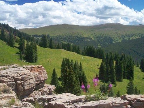
|
|
advertisement |
|
|
advertisement |