| |
| |
Shrine Pass
Shrine Pass is the most often
visited road in order to see distant views of
Mount Holy Cross. With a name like Shrine, how can
it be otherwise ? Many of the surrounding summits,
accessible by bicycle or foot, or even motor
vehicle, have more expansive views. The ridge to
the north over Commando Run is one of these
vantage points onto the northern Sawatch Range. A
little distance to the south of Shrine Pass, Ptarmigan Pass
also offers more extensive views. Instead the
vantage point from Shrine Pass has the attraction
of being historically more interesting.
From North West. In one way of thinking
Shrine Pass is little more than a 300 foot rise on
a dirt road from the top of Vail Pass. But that
also means that this approach to Shrine Pass
contains all of Vail Pass and even more. From South West. (also described upwards) From Redcliff a good all weather dirt road follows a deep, heavily forested canyon. It rarely ventures far from the valley floor to afford views of further surroundings until it approaches the meadows near the summit. A short distance below the summit a official national forest sign announces the Mount Holy Cross viewpoint trail. This is by far the most interesting spot along the route. A short, smooth, well constructed trail that can also be used by the infirm, leads to a wooden deck in the forest. The view presents Mount Holly Cross, sublimely framed by pines. Early light is best for this view. The construction of the deck is also very interesting. It resembles a church like setting. On one end a small bench sits under a wing like wooden tent structure, resembling the position of an altar. Facing it at some distance are more benches, resembling in look and function the benches in a church. Past this point, there is not much climbing involved to get to the summit, just a bit of sand maybe. But there is no need to rush away from the viewpoint. Dayrides with this point as highest summit: PARTIALLY PAVED / UNPAVED: Shrine Pass , Battle Hill Summit: Vail > Vail Pass(shp) > Shrine Pass > Redcliff > Battle Hill Summit > Minturn > Vail: 56miles (mech odo m1:91.08.24).
Dayrides with this point as intermediate
summit are on page: Searle Pass History Highways: Historically Shrine Pass was an easy way to view Mount Holy Cross. While other pilgrims by the 100s climbed nearby Notch Mountain for the image that made Mount Holy Cross famous, here you could let your motor car do the work for you. Wide spread public Interest in visiting Mount Holy Cross declined after WW2. At that time the national monument, which had been established in 1929, was decommissioned. Prior to the construction of the Vail Pass road in the
1930s, Shrine Pass was the fastest way to get from
Denver to point west, like Glenwood Springs.
Cycling: An early mountain biking guide
book that described part of this route as an out
and back ride was William M Stoehr's "Bicycling
the Backcountry", published in 1987. He lists the
route as "Vail Pass to Redcliff". |
 Approaches
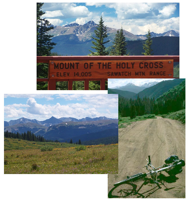
|
|
advertisement |
|
|
advertisement |