| |
|
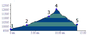
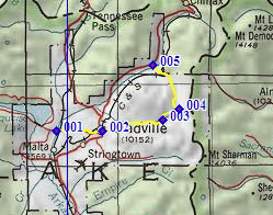
1.(9670ft,mile00) START-END SOUTH: southern Turquoise Lake access road crosses Arkansas River, just south of Leadville Junction
2.(10150ft,mile04) START-END SOUTH ALT. :jct Harrison Ave (the main street) - 7th Ave. , Leadville
3.(11190ft,mile09) Diamond Mine; road becomes much rougher
4.(12050ft,mile10) TOP: junction CR3 - Birdseye Gulch - track up Prospect Mountain
5.(10230ft,mile14) START-END NORTH: jct Co91 between Leadville and Fremont Pass - Birdseye Gulch