| |
| |
Mineral Belt Bike Path s(u)
 If you have bicycled over this
beautiful, immaculately paved bike path, chances
are you didn't really think of it as a summit. But
the fact is, that this little path climbs to an
elevation only about 70 feet below the highest
point on the Turquoise Lake Road, and the starting
points (ie lowest points) for both loops are the
same. If you have bicycled over this
beautiful, immaculately paved bike path, chances
are you didn't really think of it as a summit. But
the fact is, that this little path climbs to an
elevation only about 70 feet below the highest
point on the Turquoise Lake Road, and the starting
points (ie lowest points) for both loops are the
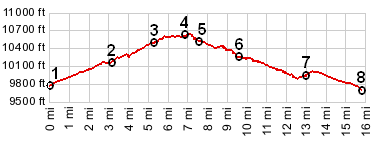
same.This is also the highest point on a completely paved loop in the immediate Leadville vicinity. The elevation difference comes to just a little over 300ft above the town, so that it falls into the category of a real summit and not a shoulder summit. But that probably doesn't interest anybody, except maybe myself. But the reasons for interest in this bike path are many. First there are the obvious reasons, the surroundings, the mountains, but not only that shimmering wall in the distance. This bike path also leads through the heart of the mining remnants, that produced enough wealth, to make this the capitol of Colorado once upon a time. Now these remnants can be described with a wide category of phrases. Historic junk, pleasing decay, historic litter, dangerous pollution deserving of the EPA superfund are just some of them. Looking at it with the eyes of a recently arrived extraterrestrial: strange decaying wood towers mark where men have toiled to get minerals out of the ground. No Swiss cheese ever fermented has so many holes in the ground as these few miles of real estate. ATV trails run around these tailings like veins through a sick leg. And through all this chaos runs a perfectly civilized, immaculately surfaced bike path, complete with wonderful, original bridges over the various gulches, that would make any republican's blood boil (because of the "money wasted on the public good"). Every ATV trail crossing is signed "caution" for the ATVers, while the bike trail users officially have the right of way ! An old mining city and a new bike path, what a wonderful combination All these historic surroundings do bring to mind the time when Leadville was the city center of the mining boom that it gave its name to. And the town has its city aspects today, like this bike path. Its twelve miles run a loop around Leadville and options to exit for its various attractions. Where the Boston beltway has its aerospace company exits, the Mineral beltway has its exits up California Gulch, Iowa Gulch, Evans Gulch - go up one - come down any other for a great unpaved ride. Then return onto the great paved bike ring road of Leadville to get back to the city.
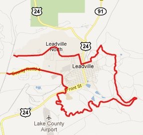
Approaches From South. In order to get the most elevation gain out of this ride, it starts on a county road. The lowest point to start any Leadville area bike ride is not Leadville, but Leadville Junction on the Arkansas River. The name refers to the place where the DRG railroad serviced Leadville. CR99 is also a starting point for the CR9 Turquoise Lake s(u) loop. Following this road east leads into Leadville to a modern looking school building with a swimming hall. You can pick up the bike path just south of there. But if you can't find it the first time, just make your way along US24, heading downhill out of town to the Stringtown area. There you will see the bike path running parallel to the road on the east side for some distance. When it reaches its southern most point, it turns uphill into the forest to the west, and crosses many great biking routes. Unfortunately they are not signed. There are lots of Leadville informational signs next to the path, regalling the rider who chooses to stop with stories of silverkings and unimaginable riches. But there is little practical information for a bike ride, no maps at all. But here are some notes on the crossings. The first paved road is CR6 to the county dump. It also leads up Iowa Gulch. An umarked single track crossing leads east to the small college campus, and I don't know yet where the trail goes on the west side. Eventually the combination of three different
railroad grades that make up this path reaches a
summit just after crossing California Gulch. This
crossing is identified with a sign. But you have
to stop to be able to read it. Behind this sign it
is a scenic view of Leadville, with a rusty old
ore cart in the immediate foreground.
From North. (described downwards) The south side of California Gulch, where the trail crests, must get very cold temperatures. Even during the end of August, when snow is still melting and not accumulating on the surrounding mountains, the aspen there have a strong tinge of yellow. The trail continues to curve and fall gently and now enters the heart of the mining district with its colorful leftovers. Getting off the trail to explore further is easy. The most obvious exit is the one leading up Evans Gulch to Mosquito Pass. The exit is loacted at a bike path bridge at the Matchless Mine, an important spot in local mining rags to riches to rags lore. Eventually the bike way crosses US24/Co91 again on the north end of town, easy to find on the north side of the local Family Dollar Store. Once on the other side of US24, the trail makes a straight run back to the modern school building. In order to keep the approaches separate the profile leaves the path at the US24 crossing and follows the northern Lake Turquoise access road to its low point. Organized Rides Personal Dayrides with this point as highest summit PARTIALLY PAVED / UNPAVED / SINGLE TRACK Mineral Belt bike trail , Colorado Trail
m171.6 section: Elbert Creek Th -Twin
Lakes s(u) , additional out and
back: lower South Elbert Th >
FR125.1B to upper Elbert Th > Colorado Trail
north > Colorado Trail m171.6 s(u) > down
Halfmoon Creek Rd > Co300 west and north >
CR5A and CR5 to Leadville > Mineral Belt bike
trail starting on the north side <> out and
back up Evans Gulch > CR38 to the first mine
>> continuing to Mineral Belt bike trail
s(u) > US24 south > CR24 south west >
Mount Elbert forebay > back to starting point:
52.2miles with 3880ft of climbing in 4:54hours
(VDO MC1.0 m3:11.9.2) |
|
|
advertisement |
|
|
advertisement |