| |
| |
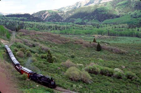
La Manga Pass
La Manga Pass and the slightly
lower Cumbres Pass pair is one of three double
summit pairs in the San Juan Mountains. It is also
the lowest pair of the three, and shares more with
the Molas/Coal
Bank double summit. Both routes follow
remnants of the DRGW railroad, that have been
converted to tourist railroads. On a busy
weekened, with some luck, the Cumbres/La Manga
ride has the best vantage points onto the remnants
of the old DRGW trains of any of these routes.
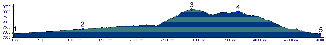
 Approaches From East.Co 17 follows the Conejos River. The most memorable part of the climb are two ramplike switchbacks, where the road leaves the Conejos in order to climb a flank of McIntyre Mountain. The view of a large, green valley to the north, direction Stunner Pass opens up below.. From West. The route starts in Chama, New
Mexico. On its way to the top, the railline
crosses the road, and at other times makes scenic
circles below it. Between Summits. This part of the eastern
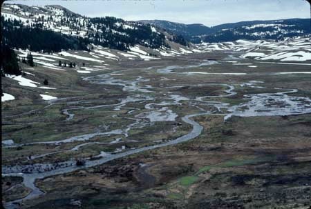
San Juans is a high rolling plateau with snow
lingering on the sides of the nroth fork of the
Rio de los Pinos till early summer.
Tours Three Day Road Tour. A Memorial Day weekend tour starting in Alamosa has been a Denver Bicycle Touring Club (DBTC) and later Heartcycle Club favorite during many past years. During some years a car shuttle between Alamosa and Antonito was used to shorten the first day. The day first day's ride ends in Chama and once measured 87 miles, using a rubber driven odometer. However, as I remember this included about 35 miles of options, scenic detours. The second day ended in Pagosa Springs, while the third day lead over Wolf Creek Pass back to Alamosa (m1:86.05.24). Another three day tour, at least once conducted
by DBTC was as follows: day 1: Antonito >
Espanola, NM (89miles); day 2: Espanola >
Chama, NM (90miles). day 3: Chama > Cumbres/La
Manga passes > Antonito (49 miles). All
mileages are odometer measured (m1:91.05.27)
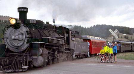
History The history of La Manga/Cumbres Pass starts like many other Colorado passes. First it was undisputed Ute territory. Then the Hayden Survey put it on the map, and their photographer, Henry Jackson popularized pictures of the area. Wagons crossed the pass in 1876. It developed into a full fledged toll road by 1879. However, the chapter of Cumbres history that still sparks the most interest is the story of the railroad. Railroads (<Williams Pass|Boreas Pass>): Here is a short recap what happened so far in this thread. In the beginning the Denver Rio Grande (DRG) railroad was heading south towards Mexico. Fortunately it was named after a closer goal, a more realistic goal, the Rio Grand River. The DRG did reach the upper Rio Grande river. It just didn't follow the river to Mexico. Instead there was closer money to be made by gouging miners for ore traffic from Leadville and Gunnison. The DRG managed to be first to reach both of these towns with railheads. But there was still more mining activity in Colorado. Alamosa, was just in the right place and already connected with Front Range cities with separate lines over Poncha Pass and Old La Veta Pass . It served as starting point for rails to Antonito and over Cumbres Pass. As usual, the DRG chose the valley route over the more direct route, wich would have gone over Stony Pass. Cumbres/La Manga passes were crossed in 1881 and rails reached Durango that same year. A year later trains reached Silverton through Animas Canyon, breaking its winter isolation. With that the DRG had captured the last of the great railroad markets in Colorado. It was the undisputed leader and was able to charge for its services whatever the market would bear. The closest competition was the DSP, now controlled by the UP. It started laying tracks across Boreas Pass. In 1920, a tunnel under the pass was seriously
considered. Instead a road was built over the top.
By 1923 it was in improved gravel condition.
Passenger service on the railroad lasted till
1951. The rails were abandoned in 1968, but
remained in that state for only two years. The
Cumbres Toltec Scenic Railway began operation in
1970. The museum railway has now been in operation
considerably longer than the original it was
modeled after. The future is the museum.
|
||||||||||||||||||||||||||||||||||||||||||||||||||||||||||||||
|
|
advertisement |
|
|
advertisement |