| |
| |
Pascoso - Gragliana s(u)
I never intended going over this
summit. But I want to also write about it, to
remind myself that sometimes getting lost is not
that bad. Actually it may have been a more
interesting route, than the one I had planned.
There must be hundreds of miles of these 2 meter
wide roads, all very well paved, threading
together countless villages and solitary stone
houses in the Alpi Apuani Mountains. Many of these
are not shown on any maps that I have seen.
From South. The profile goes over the Pescaglia San Rocco in Turrite s(u) to a low point. The way to summit described here, stays straight and climbs again. In a picturesque spot between a church and a house, that seems too narrow for any cars to pass, a sign points steeply upwards to a cemetery. It reads Matanna. Beyond this there are no more signs until the road is Serchio bound. The profile follows this very steep narrow climb to a miniature fork in the path, located at a tower of some sort. This is approximately the summit point. The profile stays right, but I chose the left at first. It seems that all paths eventually end at singular stone houses, the Apuani Park or an old car used for target practice. However on a fully suspended mountain bike I think you could continue on some of these paths, which are signed as walking trails. 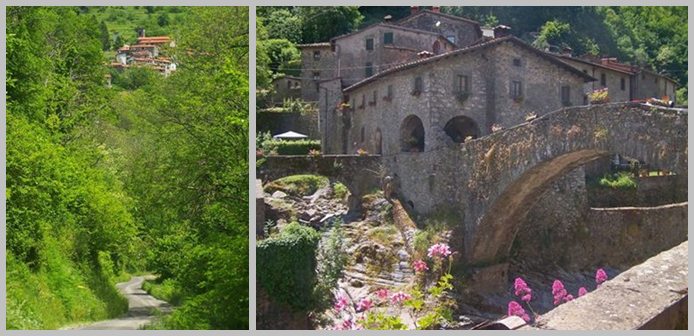 From North. (described downwards). However
staying right at the tower mentioned above,
leads to yet another set of swtichbacks down into
the valley The next small settlement at the bottom
of the has a wild photogenic aspect with an
agroturismo place nearby. In order of appearance
the list of attractions on the way down are as
follows: a nicely sculpted war memorial in front
of a small village gate, yet another hilltown far
above the road, just in case you would ever run
out of new climbing possibilities in a hundred
years or so, in the next town a Roman bridge (at
least it looks Roman to me) ormanented with
flowers, last and least a damned lake in a rugged
valley just before the first view of the town
Borgo appears on a hill on the other side of the
Sergio. Dayride ALMOST COMPLETELY PAVED Pascoso - Gragliana s(u) , Pescaglia - San
Rocco in Turrite s(u) , SP7 Barga(sh) :
Borgo in Mozzano > Diecimo > Fondagno >
Piazzanello > Pescaglia > Pescaglia - San
Rocco in Turrite s(u) > Pascoso <> out
and back beyond end of pavementos ocn a number of
small roads south and west >> Pascoso
- Gragliana s(u) > Gragliana > back down
into Serchio Valley, east side of river > up
SP7 > Barga with detours > SP7 Barga(sh)
> back down to Serchio Valley > back to
starting point on east side of river:
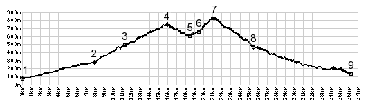
56.2miles with 5900ft of climbing in 6:02hrs
(Garmin etrex e30 m4:14.5.26} The last day with different start and end points
is on page: Col de
Bigorno 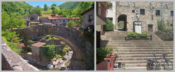
|

|
|
advertisement |
|
|
advertisement |