| |
| |
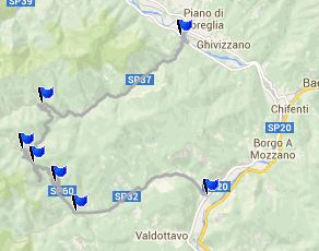
Pescaglia - San Rocco in
Turrite s(u)
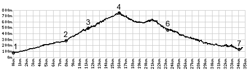
This is a small summit, that
serves as demonstration what makes the riding here
so pleasant and scenic. But probably the best
aspect is, that it seems that there are dozens of
summits like these just waiting to be discovered
by riders who are just bike wandering around. And
should one ever run out of two summits, there are
inumerable one way climbs to 7th century churches
and old villages. But the pavement is from the
pleasant present.
The first intersection contains what seems like
half a dozen names, that I still can't find on my
map. But all of them have a ring to them and
promise to be hidden spots in the mountains. The
only thing I know about this intersection, is that
the comes down from Passo
del Lucese, and that is something the over a
dozen of signs do not tell you. From North. The profile descends this small dip and turns right to descend back down to the valley of the Serchio. Going straight is probably one of the most interesting places to get lost that I know of, and the chances that one will get lost are very high. More on the Pascoso -Gragliana page. A Dayride with this point as intermediate
summit is on the page: Pascoso -
Gragliana s(u)
|
|
|
advertisement |
|
|
advertisement |