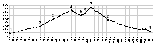
1.(80m,00.0km) START-END SOUTH: jct SP2 - road to
Pascoso
2.(283m,8.0km) profile turns right at this signed four
way intersection in Trebbio.
3.(458m,10.9km) Pescaglia
4.(740m,16.0km) Pescaglia - San Rocco in Turrite s(u)
5.(590m,18.3km) road on right keeps going downhill to
Serchio Valley
6.(655m,19.5km) Pascoso
7.(845m,21.1km) TOP: Pascoso - Gragliana s(u); profile
turns right at this intersection, even if I did not
8.(470m,25.6km) Gragliana
9.(150m,36.2km) START-END NORTH: sp20 bridge over
Serchio, east of Fornaci Di Barga