| |
| |
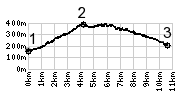
SP7 Barga(sh)
I don't think this summit will
ever make it into a book, dedicated to climbing
with a bicycle. It is small compared to other
possibilities. Just by taking a right turn along
this road somewhere, you can climb quite a bit
higher summit points, (as indicated by the (sh)
for shoulder summit). But sometimes less is more,
especially during the times, when resting up for
when "more is more" again.
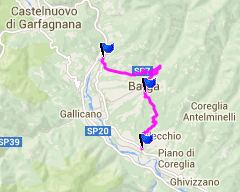
Sightseeing and bicycling are the perfect combination. This also goes for somewhat toursity spots like this one. Barga is on a hill and the highest spot in town is the dome.
Just before the first view of the town appears, a
sing in English calls this the most Scottish town
in Italy. It must have something to do with the
Scottish looking castle tower on what is supposed
to be a church. The highest spot in town is this
Scottish dome. From East. Shortly
after the diversion through narrow medieval steets
a sign points out the next, and in this case last
step on the ladder up the hilltowns: Renald, and
also an out and back to Vitricia. But this profile
stays on SP7 and descends back down to the river
Serchio A Dayride with this point as
intermediate summit is on page: Pascoso -
Gragliana s(u)
|
|
|
advertisement |
|
|
advertisement |