| |
| |
Tunnel de Parpaillon s(u)
If I were lucky
enough to live nearby I would have waited till
later in the year for a ride over - or better
through - this summit. But this is probably the
only chance I am going to get, to ride through
this famous tunnel. French filmmaker Luc Moullet
made a film in 1992 about crossing this route on a
bicycle. So I tried to do this route when I was
here, early June, when there was still quite a bit
of snow in the mountains
There is also a trail over the Col du Parpaillon, located above the tunnel at 2780 meters. Both routes connect the valleys of the Ubaye with the valley of the Durance. Google Maps, as well as some signs also refer to the tunnel entrance as Col del Parpaillon, as well as "Tunnel et Col du Parpaillon"
From South. In the collection of houses
at la Condamine in the Ubaye Valley, a road starts
to climb to St Anne. Soon afterwards you pass a
sign: "Tunnel Parpaillon - Ferme". Apparently the
sign, stating that the tunnel is closed, has
always been there, and - all the same - the doors
have always been open. Some of the lower
switchbacks afford the best views of Fort Tornoux,
a fortification from the "Little Maginot" or
Alpine line, an immense fortification against
attacks from the other side of the mountains.
After about 1350ft of climbing you enter St Anne,
location of the exceptional Gite Belvedere. The
road continues on pavement through larch forest,
passing some old stone houses with monumental
walls. The pavement ends at an informational
tablet about the tunnel. Subsequently a small
bridge over a side stream does a lot to restrict
traffic. Past this point cyclists and hikers will
not have to put up with heavy cars, just in case
there were any before. A second much sturdier
stone bridge crosses is reached further up, at
about treeline.
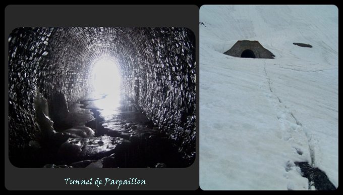
From East. These were the
conditions during a first week in June. The first
20 or 30 meters were on about 40cm thick ice, but
melting water had eroded a ditch of sorts into it.
Past that I could see a tiny bright dot on the
other side, the other portal. The ice gradually
thinned as I walked and carried my bike into the
tunnel, and then I was on solid ground. About
halfways into the tunnel the ice started up again,
with a little water on top. Several meters later,
the ice broke on every step with about 6 or 10 cm
of water below it. It meant wet feet, but actually
walking was no problem, because the surface below
the ice was flat. The other portal on the north
side was completely surrounded by snow. The very
top of an "icy road" sign was visible in a surface
of deep snow. Somewhere below it the road was
buried. From here I could recognize a partially
melted out road, maybe 1km down the valley. The
terrain is fairly gentle on this side, so making
my way through the snow downhill was obviousely
not as fast as bicycling usually is, but it wasn't
any slower than walking would be.
After loosing about 300m in
altitude, I met the first vehicles, that had given
up ascending from this side. I have to admit my
"bonjours" had a special pride in them during this
descent. Pavement starts back up about 2000ft
below the portal. Signs on this side refer to the
crossing as "Col Parpaillon", even thought most
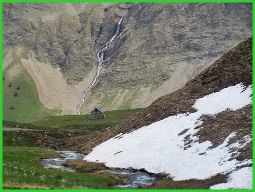
people really refer to a tunnel and not a "pass".
Here the valley looks amazingly similar to a scene
from the Canadian Rockies next to the Icefields
Parkway. The similarity lies in the waterfalls
that tumble from sheer heights over vertical
cliffs of twisted sedimentary rock layers,
crumbling like a croissant. But this National Park
has free access, and you can mountain bike through
it. It seems sometimes the Canadian Rockies are
reserved either for tourists, purchasing 40 dollar
snowcat tickets, or the bears.
History The history of this tunnel is really the history of the border conflicts between, what is now the Italian Piedmont region and the Ubaye valley. The strategic location of Fort Tournoux was already recognized in the second century BC. The name of the fort bears testimony to this. Tournoux is derived from "Turnus", a Roman general who was sent into the alps in 219 BC to oppose the troops of Hannibal. Repeatetly the spot overlooking the 4km at the
convergence of the col
du Vars and Col
du Larche, became a battleground. In the
middle ages it was the Lombards, who crossed from
the now Italian side, then the Saracens. Countless
others followed during the complicated history of
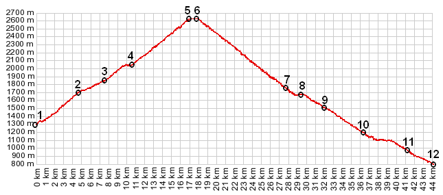
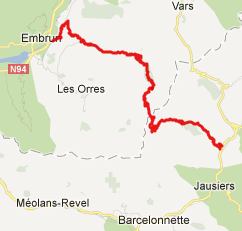
European conflicts. Cycling: An issue of Centcols describes the attractions that this pass has had even on cyclists of an earlier period, and names a cyclist who crossed the pass in 1903 - two years after its completion. By 1930 the title "legend" is used to describe it and a group of 29 cyclists visit it. Dayride PARTIALLY PAVED / UNPAVED Tunnel de Parpaillon s(u) , Col du Vars: St
Anne la Condamine > Tunnel de Parpaillon s(u)
> D994D north > Suguet > Guillestre >
Vars > Col du Vars > la Condamine > sp
62.5miles with 8680ft of climbing in 7:34hrs (VDO
MC1.0 m4;12.6.7)
The last day of an Extended Tour with different start and end points was: Col de Larche |
 Approaches
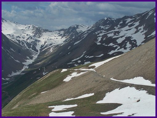
|
|
advertisement |
|
|
advertisement |