| |
|
|
|
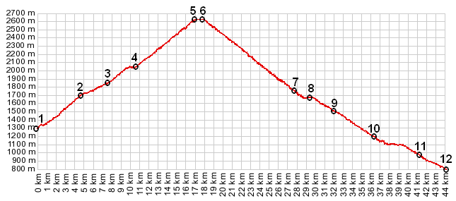
01.(00.0km,1290m) START-END EAST: la Condamine in Ubaye Valley
02.(04.6km,1691m) St Anne
03.(07.7km,1861m) bridge over le Berard
04.(10.7km,2057m) road forks; profile follows uphill route on right
05.(17.0km,2637m) TOP: southern tunnel entrance Tunnel de Parpaillon s(u)
06.(17.5km,2637m) TOP: northern tunnel entrance
07.(27.5km,1731m) fork in road. Profile follows paved road on right to La Chalp
08.(29.5km,1655m) La Chalp
09.(32.0km,1480m) upper turnoff to Praveyral
10.(36.5km,1145m) profile stays right towards le Villard
11.(41.2km,918m) START-END WEST ALT: a hard right turn leads upvalley towards Guillestre on a very nice road; profile continues straight
12.(440km,801m) START-END WEST: le Pont Peuf north of Embrun
|
|