| |
| |
Col de Larche
aka Colle della Maddalena Col de Larche
reaches almost 2000 meters, but unlike other
passes at this elevation, the road does not have
to engage in the same civil engineering
acrobatics. You can already see from any map that
two relatively gentle valleys meet at the top. A
historic thoroughfare between Italy and France is
the result.
One website directed at cyclists advises to cross this pass from west to east. I just happened to do the opposite. So here is the description of the not recommended crossing.
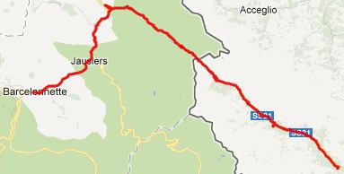
From East. The description starts some
distance before the elevation profile. S21 going
up the Stura valley from Burgo San Dalmazzo is
pretty narrow and has a lot of traffic. But the
signed bike route is a much better option. The
signed "Itinerario Stura Valley" route starts just
before S21 crosses the river and leads on
continues for its entire length on the opposite
side of the river. This narrow road looks just
like a bike path most of the time. But it's a road
- and you do encounter a few cars on it. Benches
for lunch stops are rare in this part of Europe,
but there's at least one on this route in Fetiona.
Past Demonte the views of villages on the opposite
side get more interestion. West of Vinadio it's
easy to confuse the Stura Valley route with the
road up Colle di Lombarda. Instead the Itinerario
Stura Valley route towards Col de Larche keeps on
heading for the same peaks that have been in the
field of view for the last several miles. The bike
route soon ends after this crossing. But during my
ride in early June, I didn't encounter much
traffic at this point on the road either.
Past the town Larche the views of high mountain
peaks give way to a deep gorge. This is the only
portion where the road requires switch backs. Past
that the road merges with the descend from Col du Vars and then
follows a canyon into the Ubaye valley past la
Condamine to Jausiers and Barcelonnette. History This is a natural
border crossing between France and Italy, and
since conditions have not always been as peaceful
as they are now, the pass was of great military
interest. It is speculated that it was used
already by Hannibal in 218 to cross the alps. During the war of
Austrian Succession, the first considerable
defense structures on a perfect vantage point,
overlooking the now (French) approach of Col du
Larche were built. The side was chosen to guard
against Austrian and Piedmontese attacks.
Eventually this became the site of Fort Tournoux,
a spectacularly located mountain fort, as part of
the Little Maginot Line of WW2. Eventually it was
taken by Germans and remained a last pocket of
resistance, long after Provence had been taken
back by the Allies. 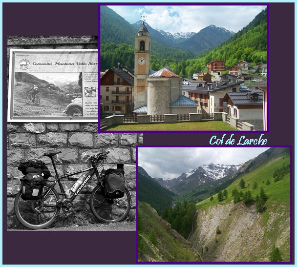 A day on a Tour: (<Col du Tende|Col de Pontis>)
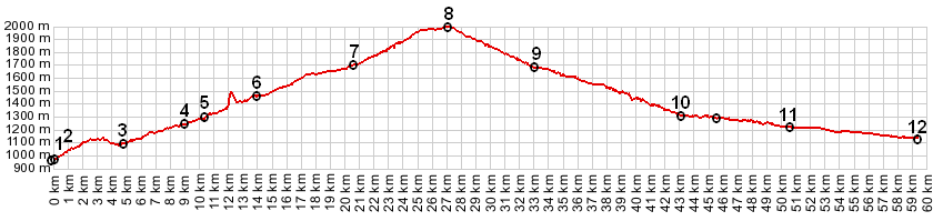
Colle della Madalenna/Col du Larche: Demonte > Itinerario Stura Valley bike route > Colle della Madalenna/ Col du Larche > Jausiers << turning back to St Anne la Condamine: 50.3miles with 5810ft of climbing in 5:12hrs (VDO MC1.0 m4:12.6.3) Dayrides from the ending point of this day, St Anne la Condamine, (near Barcelonnettte) are on page: Col de la Cayolle Tunnel de Parpaillon |
 Approaches
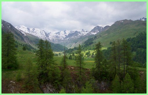 A
long tunnel past Sambuco marks a scenic
transition. Below are the high limestone walls of
the Stura Valley. Above the landscape looks more
like a high alpine valley. The villages here are
resort towns, but don't look overly
commercialized. Past Argenterra, it appears like 8
or 10 gentle switchbacks lead to the top of the
pass. But once up there, there is a second set.
Then the valley levels out above treeline, passes
a lake with restaurant still on the Italian side
and the road climbs a gentle saddle. The top
contains a parking lot and at least one large
building. An internet page mentions a nearby
monument to cyclist Fausto Coppi. I didn't see it.
Maybe you have to search the distant corners of
the large parking lot.
A
long tunnel past Sambuco marks a scenic
transition. Below are the high limestone walls of
the Stura Valley. Above the landscape looks more
like a high alpine valley. The villages here are
resort towns, but don't look overly
commercialized. Past Argenterra, it appears like 8
or 10 gentle switchbacks lead to the top of the
pass. But once up there, there is a second set.
Then the valley levels out above treeline, passes
a lake with restaurant still on the Italian side
and the road climbs a gentle saddle. The top
contains a parking lot and at least one large
building. An internet page mentions a nearby
monument to cyclist Fausto Coppi. I didn't see it.
Maybe you have to search the distant corners of
the large parking lot.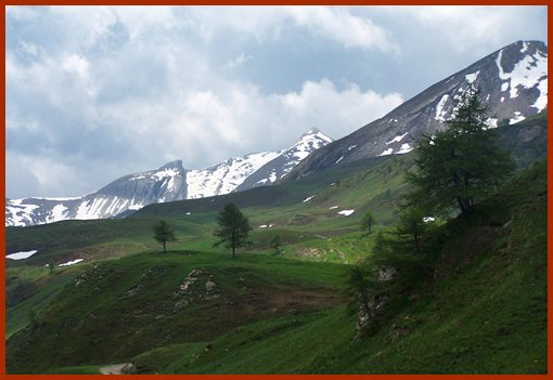 From West. (described
downwards). The French side is drier and the
resulting mountain vistas have quite a bit more
grandeur than on the Italian side. If the light
deteriorates in the afternoon, you see much more
of it if you ascend on this side. This is reason
why a west to east ride may be better.
From West. (described
downwards). The French side is drier and the
resulting mountain vistas have quite a bit more
grandeur than on the Italian side. If the light
deteriorates in the afternoon, you see much more
of it if you ascend on this side. This is reason
why a west to east ride may be better. |
|
advertisement |
|
|
advertisement |