| |
| |
Passo di Gavia
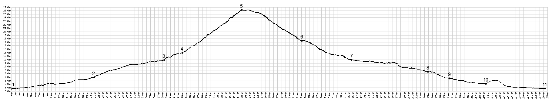
Gavia is a great massive crossing of the central alps. It is a very popular ride. It is also a crossing with a long history. But from the narrow road, that allows only small vehicles (no trucks allowed), you would never suspect the length of time, that people have crossed the main range of the alps here. Still - the road remains very narrow. Today this ride would be even better if the road size could accommodate the crowds - or vice versa. - The practical solution is: just pick an unpopular day to ride a bike across it.
The valley becomes more visually interesting
north of Breno. The towns up in the hills take on
a more spectacular appearance. You could say that
something like a "pass road" starts above Edolo
and its crazy chaotic town center. The road still
stays in the valley, but now it climbs smore
steeply, towards Passo di Gavia and Passo del
Tonale. Following road signs for Passo Gavia leads around
the town Ponte di Legno. This option follows up
the first switchback toward Passo del Tonale, only
to turn off onto the road to Passo Gavia and
practically descent into Ponte di Legno again. The
aproximately 100 meters of extra climbin do not
make that much of a difference, but I probably had
about 60 lbs in touring equipment attached to my
mountain bike, and the extra climbing effort did
make a difference. The profile above takes an
earlier turnoff through the town Ponte di Legno. This is the start of a massive climb, and the
scenery is grandiose and spectacular, but it
changes very little. Finally the road starts to
leave the V shaped bottom of the valley and climbs
up the western slope in long switchbacks. I found
a nice bench to have lunch on after the first 1000
meters of climbing for the day.
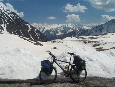
But in any case, there were still few enough cars
and motorcycles, that it is possible to take
pictures of the pass road without them, as is
demonstrated here. The massive view behind changes
slowly. With elevation gain the peaks behind the
peaks rise in stature. Looking at this now on the
map, it becomes clear that these massive ranges
are elegant room dividers for Italy. Hard to
believe that behind that vertical wall already
lies Lago di Garda, three days worth of riding
away for me (but I rode a few detours), and much
lower in elevation than where I started today. Meanwhile the road has become a little wider
again and is now solidly above treeline. I was
just thinking, how rare it is around here to find
a pass road with no tunnels, no bridges, no civil
engineering marvels, just grand scenery,
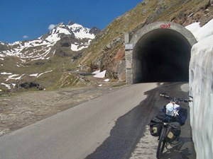
when ... I found myself at the entrance of a
long tunnel. And to make me pay for my thoughts,
the tunnel was uphill, and not very well lit. With
all that weight on the bike I decided to walk the
second half. I learned only late that apparently
there is a very scenic rough detour around the
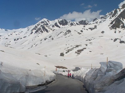
800m tunnel avaiable for bicycles. Exiting the tunnel the view shed has not really
changed. But there is a new vantage point on the
road ahead, a last series of steep switchbacks,
and somewhere above these snowfields and all these
zigs and zags must lead to a crossing. The top has a restaurant/albergo, and generally the motorcycles outnumber the bicycles parked there by a large amount.
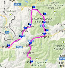
From here a wide road descends into Bormio,
passing villages with monumental houses. The
housing style shows the proximity of Switzerland,
where intricately painted holy figures on
fountains and in house alcoves are also common.
Bormio is a fairly expensive ski resort in an
exquisite mountain setting ( but a rock bottom
bargain compared to nearby Switzerland ) with many
historically fascinating bridges and town blocks. Historical Notes: Archeological finds on the north side of the pass indicate that this pass has been used in the stone age. During the late middle ages the Venetians built a better trail over the pass to thread a way between the Hapsburg Austro-Hungarian empire on one side, and the Lombards on the other. At the end of the 16th century Venetian traffic increased drastically, and the name "Strada Imperiale" was used for the crossing. With the decline of the Venetians came also the decline in the popularity of this route. The road across the pass dates back to the time of WW1. Cycling: When the Giro d'Italia first
crossed this pass in 1960 it was still unpaved. It
was scheduled to be on the route again the
following year. But this was only the first of
several occurrences when the crossing was
canceled. More cancellations occured in 1984,
1988, and 2013. But the successful Giro crossings
outnumber the cancellations: 96, 99, 04, 06, 08
and 10. A Day on a Tour: COMPLETELY PAVED: ( < Colle San
Zemo | Col du
Mont Cenis > ) Dayrides between this and the next day with
different start and end points are on pages:
|
 The second thousand meters
were harder. The road becomes very narrow.
This would be a great thing, if this were a side
road that hardly anybody travels on. But on this
sunny weekend there were 1000s of motorcycles
from Austria, Germany, Italy, not to mention
Poland, a Chech Ferrari ralley, and various other
motor enthusiast niche groups, that I could not
identify, because I choose blissful ignorance
about these things.
The second thousand meters
were harder. The road becomes very narrow.
This would be a great thing, if this were a side
road that hardly anybody travels on. But on this
sunny weekend there were 1000s of motorcycles
from Austria, Germany, Italy, not to mention
Poland, a Chech Ferrari ralley, and various other
motor enthusiast niche groups, that I could not
identify, because I choose blissful ignorance
about these things.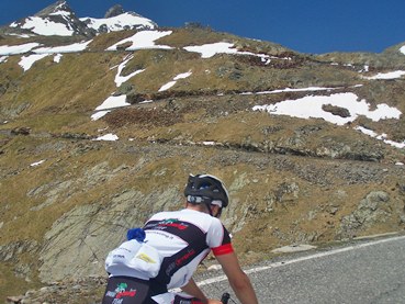
|
|
advertisement |
|
|
advertisement |