| |
| |
SP212 Moncenisio(sh)
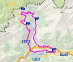
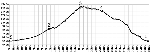
The road from Susa to Moncenisio is a beautiful, remote, alternate route to the lower approach to Col Mont Cenis. But you can also view this point as a shoulder summit in Moncenisio, with the Mont Cenis Road as the other approach. That's what the profile below does. This is also the western end of the bicycle road (cars allowed) through the Susa Valley. Even with a topo map, the topology here can be confusing. The road starts in the valley and ends on the main road towards Mount Cenis Pass. I think that much I said already with all those words above. But how much extra climbing does it involve on the way to Mont Cenis, when compared to staying on the Mt Cenis main road all the way? The map may give the impression, that the road has to negotiate a considerable additional drop when returning from Moncenisio to the main road. But in reality actually looses only about a hundred meters.
 From East. Following this
road up from Susa is a pure joy. My favorite part
is passing through Novalesa. A bicycle seems like
the perfectly sized vehicle on its main street,
about as wide as a car. Countless yet narrower
walkways terminate in this urban slot canyon of a
street. Suddenly a church shows up in this narrow
world, where every meter of progress brings a new
surprise. From East. Following this
road up from Susa is a pure joy. My favorite part
is passing through Novalesa. A bicycle seems like
the perfectly sized vehicle on its main street,
about as wide as a car. Countless yet narrower
walkways terminate in this urban slot canyon of a
street. Suddenly a church shows up in this narrow
world, where every meter of progress brings a new
surprise.After the sightseeing ride comes the real work: miniature switchbacks, lots of them, only the steepness is not miniaturized. It helps to know, that all this actually counts toward climbing Mount Cenis Pass, if that is the destination, though it may not be the easiest way. The switchbacks end, but one look at the topography on the map, and you know you must keep climbing. But now the road tries its best to change it into contouring along the hillside. The top comes as a complete surprise, the entrance to a small village, organized around a small lake in the woods. Several businesses also deal with visitors. From West. So what does the road do here ? The map makes it look (at least to me) like it just goes back down parallel to where it came up. This would be wasteful if trying to get to Mount Cenis. However in reality the road contours along a ridge, presenting several more scenic views of the ridge, crowned with deep snow above the clouds. Somewhere below is Susa, but you can't see it. The road only looses about 100 meters before merging with the main road to Mount Cenis. The profile takes the way back down to Susa. It just may be, that this little summit is a lot more appropriate as an day ride free of heavy loads, rather than trying to get up it with a fully loaded touring bik, bound for Mt Cenis Pass (as I did). A Day on a tour with this point as intermediate summit is on page: Mount Cenis Pass
|
|
|
advertisement |
|
|
advertisement |