|
|||||||||||||||||
|
|
|||||||||||||||||
|
|
Col de Tende
aka Colle di Tenda
This is usually thought of as the most southerly of the big
and important passes in the alps. The two special things
about this pass are: One: the amazing number of regular
switchbacks, stacked up on top of one another as part of an
old unpaved road on the French side. Two: the historical
importance of this crossing, resulting in a immensely
fortified ridgeline. The ruins of these fortifications
remain. In a way this is like a visit in a museum, but
without the crowds or fees that are often connected with
such a visit.
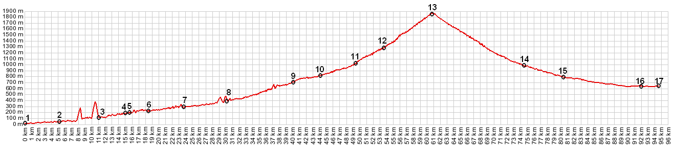
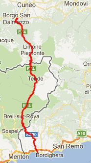
From South. The profile starts with a big
old highway bridge in Ventimiglia,There are probably plenty of
ways to go around it, but why bother ? The highway bridge works
just fine, and it is easy to find on the first try by following
simple road signs. Once past the bridge, S20 enters the canyon
of the river Roya. The route follows S20 and the river all the
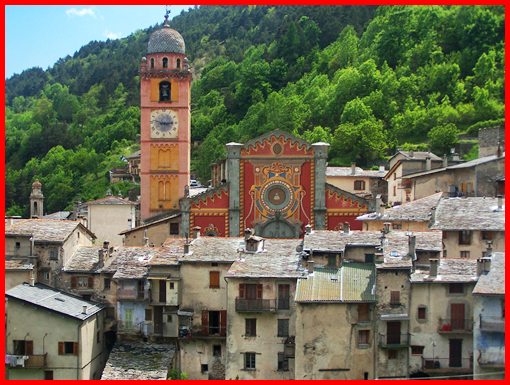
way to the town Tende. Meanwhile the road crosses into France. Glimpses of hilltowns far above the canyon make this ride as fascinating as many of the adjacent southern canyons: the towns Fanghetto, Saorge, la Brigue, and maybe best of all, Tende itself. Tende has all the infrastructure for a good base
location to explore the surrounding mountains on a mountain
bike. A sports shop, a municipal campground, that also rents
reasonable simple rooms, 2 medium to small food stores
(including 1 Spar shop), and a tourist department. Even if it's
closed, there is a map displayed north east of the center of
town, that shows the principal mountain biking routes. Just
about all of them involve Col de Tende in some way. But the
nicest thing about Tende is the old medieval town itself. You
really don't need a day of rain, and an excuse not to bicycle,
and to explore the town instead. My favorite spot is the
cemetery, also the highest point of the town.
Most descriptions of the pass start in Tende.
Past the town the road gradually gets steeper. Even before the
old pass road branches off the newer tunnel route, I count 9
switchbacks. Apparently there is also another secondary road
that bypasses some of these lower switchbacks. It is signed as
"no car traffic - sauf souverains (local traffic
only)". At this point you can already see the goal, the old
central military fort above, and in the morning light it doesn't
really look that high. Just before the tunnel a hard left takes
you onto the old pass road, and then the switchbacks really
start. There are 48 of them, regularly spaced on a narrow road,
like a staircase. A few of the switchbacks are numbered. The
dirt road does not start until switchback 28 or a little above.
Compared with the other military roads, that leave from the pass
(now MTB trails) this dirt road is in really good condition. I
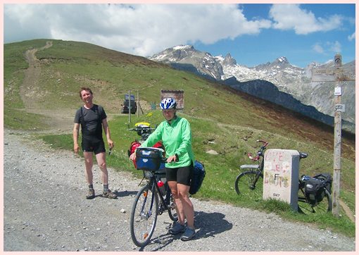
met a cycling couple with fully loaded regular touring bikes on
top. They made it from Tende to the pass by about lunch time.
The connecting ramps tend to get longer and longer, making you
think that you have made more progress than is actually the
case. By the time you climb above treeline the ramps are many
times as long, as they were in the beginning of the climb.
From North. (described downwards). I had
the feeling I missed the south side as soon as I started rolling
down the north side. All the medieval hill architecture is gone,
suddenly replaced by ski hotels, pretty much all closed when I
was there. Mountain views are also not as good, at least in
morning light. There is also a short unpaved section, a little
distance below the top on this side. Past Limone the route
converges with the traffic from the tunnel, and there are a few
short sections that could be described as unpleasant due to
traffic and an abrupt road edge. But it is really no problem, at
least in a downward direction. - The tunnel is open alternately
in each direction. So the traffic exits the tunnel bunched up
into convoys, then a long time - nothing. Quite far down the
valley, somewhere around Robilante a bike path starts. But all
the racers still seem to use the road. Unlike the French side,
there are plenty of industry and shops on this side, and this
gets heavier the closer you get to Cuneo. Now there is no
problem to find the foods you've been doing without on the
medieval French side. History Ancient to Medieval times: You would suspect that people have been following up the canyon of the river Roya for a long time, and that people have been wandering up into the mountains above Tende for nearly just as long. It turns out that a Greek geographer by the name of Str_abo already mentioned this pass. He was then quoted by Roman authors Varro and Servius. It is widely speculated that the Hannibal with his elephants ascended the (now) French side of the pass, when he started out on the Iberian peninsula to invade the Roman empire from the south. A mention of a highway between
Ventimiglia and Borgo San Dalmazzo, ie the route of the profile,
goes back to 1178. It was used as a salt trading route into the
alps. Tende provided surveillance and maintenance for the road.
During the middle ages the road was reinforced and the entire
Roya valley prospered from this work, controlled by the town of
Tende. Napoleon: During the mid
18th century, this was one of many pass roads that was improved
by Napoleon. For the sake of easier troop movements, the road
bed became better engineered, the slope was made gentler, the
surface harder and more even. World War 1 and 2: The remnants of the fortifications that we see to today on the ridge line were built in 1877 trough 1880 by the Italian Piedmont, then fortified into a series of six buildings, in order to be of advantage in conflicts with the area to the south. The pass played a big role in the
various complicated twists and and turns, resulting in wars that
Europe fought with itself. The last one of these is WW2, when
France captured the pass, along with the already built tunnel.
With the "Treaty of "Paris" following WW2, de
Gaulle insisted that the Italian French border runs well north
of the ridge line, thus giving France the entire ridgeline with
its forts and fortifications. Cycling: The paved nothern
approach from Vernante over Limone was used by the Giro d'Italia
in 2005. Earlier the Tour de France ran over the top twice, 1952
on a 251km monster stage between Sestriere and Monaco, and in
1961 on a 225km stage between Turin to Antibes and Juan-les-Pins A day on a tour: (<Col
de Castillon|Col de Larche>)
Tende > Col de Tende > Limone > Borge S. Dalmazzo
> up the Itinerario Valle Stura signed bike route >
Demonte: 53.8miles with 5610ft of climbing in 5:22hrs
(m4:12.6.1).
A dayride from the
starting point of this day, Tende, is on page Via
del Sale s(u)
A dayride from the ending point of this day, Demonte, is on page: Colle Fauniera
back to Cycling
Passes in Europe
|
 Approaches