| |
| |
Old La Veta Pass
Old La Veta Pass is a 5 mile
stretch of deteriorating highway, south of the
modern highway. Much of it is heavily forested,
instead of sage covered like "North La Veta Pass".
An abandoned settlement and a peaceful road
through an area, rich with history, provide a
completely different experience than a race over
the top of North
La Veta Pass. The profiled eastern
approach substitutes an additional 13 miles of
pleasant unpaved road biking, that are
different from the North La Veta Pass
route.
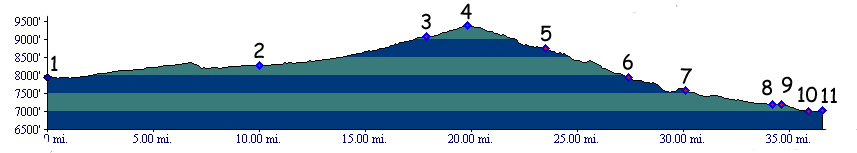
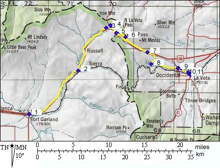
From West. The first 18 miles of this approach are identical to the "North La Veta Pass" approach. This portion is a modern highway and is shown between point 1 and 3 on the profile. Starting at point 3 a deteriorating old highway follows an old railbed for an alternate route to the summit. From East. The route described in the
profile is identical to the "North La Veta Pass"
profile between points 5 and 6, a distance of only
4 miles. The suggested route above point 4 follows
the historical railbed, while the route below
point 6 follows rural dirtroads into La Veta. This
is not the old railbed, but a pleasant and shorter
fat tire alternative to the racecar traffic on the
highway. Fine views of the Spanish Peaks, quite
different from ones obtainable on the North La Veta Pass
route are seen form above the Muleshoe Curve area. A Dayride with this point as
intermediate summit is on page: North La Veta Pass
History The story of this ridge crossing really starts
with the history of North La Veta Pass
and Pass Creek Pass.
Geographically this is just another variation of
the route over La Veta Pass. Historically the area
is de Anza's gateway to the north, the venerable
old Sangre de Cristo Pass. As if that wasn't
enough historical signficance already, the
Old La Veta Pass variation of the crossing
represents another first for Colorado. It became
the first Colorado pass to be surveyed for a
possible railroad, and much later the first to be
crossed by a completely different railroad. Gunnison Railroad Survey (Mosca Pass>) Sangre
de Cristo Pass was the first pass surveyed by an
expedition of US topographical engineers in search
of a transcontinental rail route. The year was
1853, a full 15 years before the first
transcontinental railroad was actually built. The
old Spanish path over the pass was too rough for
wagons. Consequently Captain Gunnsion cut a six
mile long path, a short distance to the west of
the pass. This puts the route closer to Pass Creek Pass
in places. The most consequential discoveries on
Gunnison expedition were made later, after
crossing Cochetopa
Pass. Railroads (<Monument Divide|Raton Pass>): The old Sangre de Cristo Pass was eventually crossed by rails, not by the first transicontinental rails, but it was the first Colorado mountain pass for such an undertaking. When Palmer's Denver Rio Grand railroad reached Pueblo, there were two possibilities to lay rails to the Rio Grande, the river so prominently featured in the company logo. Plan A : go south from Canyon City along the Front Range to Trinidad, cross Raton Pass and after that - who knows ? Alternatively you could cross into the San Luis Valley by going up the Arkansas valley and over Poncho Pass. In the grand scheme of the DRG railroad at the time - to get to El Paso, Texas on the Mexican border- this route detours too far west. The confusion between the two routes was cleared
up by the profit motif. The coal fields of El
Moro, near Trinidad became more important than
distant Mexico or even Texas. This meant
continuing to lay track south along the Front
Range. Past Pueblo, Palmer's Rio Grande had
company, the Santa Fe Railroad. The Santa Fe
railroad did not come from Santa Fe. It was trying
to get there, and after that - across the
continent - for more landgrants. Its tracks
arrived across Kansas and eastern Colorado. Its
owner was already rich from controlling the cattle
traffic from Texas. They were heading for the same
gap in the mountains, but there was only enough
room for one railroad to use it. No, it was not La
Veta Pass, but rather Raton
Pass. Even before the conflict at Raton erupted, Palmer
(of the DRG) noted the heavy wagon traffic along
Sangre de Cristo (La Veta) pass, headed for Del
Norte, Stony Pass
and Silverton. The Denver Rio Grande could profit
from that traffic. Plan C became a possibility.
Cross to the Rio Grande over La Veta Pass. The railroad approach did not follow the previous trails across Sangre de Cristo Pass. A large muleshoe curve was laid around "dump mountain". The name was chosen not so much to express a lack of appreciation of form for the mountain. To them it just looked like a dump in front of a mine. They were paid to lay track, not to come up with pretty names. The grade on this first Rocky Mountain rail crossing reached 3 to 4 percent to the mile, compared with less than 2 percent on the transcontinental line. Palmer used plain dirt as ballast on the rails, instead of stone. He wasn't trying to build an engineering monument for the future. No, he was downright surprised himself that it worked in the first place. On the other side of the mountains Palmer founded yet another land grab city, Garland City. A year later in June 1878, the railroad reached its first objective towards Mexico, Alamosa on the upper Rio Grande. The second pass in Colorado, to be crossed by a railroad became Raton Pass Old La Veta Pass and its sand ballasted rails did
not remain in operation for long. In 1890 the DRG
relocated its rails to a pass seven miles south.
That pass, previously called Wagon Creek Pass,
became Veta Pass. Old La Veta Pass was rebuilt as
a stage road and much later as an automotive road.
The modern road, North
La Veta Pass was built in the 1960s. The
only thing left to mention is that prior to the
building of North
La Veta Pass, Old La Veta Pass was known as
La Veta Pass (not to be confused with Veta Pass),
since there was no reason to distinguish between
the new and old roads. Many US government maps
still have the old label. Today however, the
North is often dropped from the "North La Veta Pass"
label, since it is the dominant crossing. This
confusion can be avoided by always referring to
the passes in question as either "North La Veta Pass"
or "Old La Veta Pass", since La Veta pass referred
to different crossings throughout history. |
 Approaches
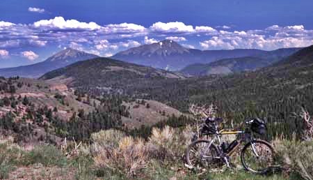
|
|
advertisement |
|
|
advertisement |