| |
|
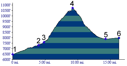
1.(mile00,6470ft) START-END EAST: junction of Hayden Pass road with US50 near Coaldale
2.(mile05,7300ft) Coaldale campground
3.(mile05,7590ft) Rainbow trail crosses
4.(mile10,10709ft) TOP: Hayden Pass
5.(mile15,7890ft) low point crossing Rock Creek
6.(mile17,7980ft) START-END WEST: Villa Grove on US285