| |
|
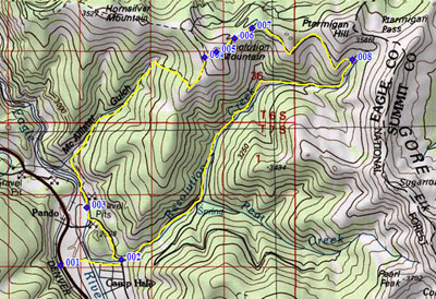
1.(9240ft,mile00) START-END WEST-1: jct Co24 - northern entrance road to Camp Hale
2.(9210ft,mile02) profile goes left on FR708 Mc Allister Gulch
3.(9200ft,mile02) low point
4.(11600ft,mile06) profile goes right, to top of Resolution Mountain
5.(11905ft,mile06) TOP: Resolution Mountain
6.(11490ft,mile07) Fowler-Hilliard Hut
7.(11450ft,mile07) profile turns right onto FR751
8.(11350ft,mile09) profile turns right down FR702: Resolution Creek
9.(9240ft,mile14) START-END WEST-2: same as point 2