| |
| |
Colorado Trail m139.9 (sh)
(section: Camp Hale - Tennesee
Pass Rd crossing)
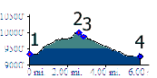
Between Camp Hale and the top of Tennessee Pass,
the Colorado Trail stays relatively close to the
Tennessee Pass road. Several access points along
the way make it possible to separate the trail
into very short sections. This shoulder summit
combines a short portion of the trail with a part
of the Tennessee Pass road into a loop. For a
bigger view, this section of the Colorado Trail is
also included in the next section: Colorado Trail
m148.8(sh) (section: Camp Hale - Long
Gulch).
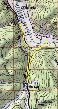
From East. When coming down
from Kokomo Pass,
the Colorado Trail turns off to the south before
it really enters Camp Hale. The turnoff onto
FR741C is marked. But this is one of the few CT
junctions, that could actually be missed if you
don't look closely. The road leads to the end of
a long Camp Hale housing structure of some sort.
Here the CT crosses a small bridge and heads for
an eminently ridable single track in the trees.
This section is not quite as smooth as the next
section on the west side of the Tennessee Pass
Road, but it comes close in places. There is
every indication that this trail has been
prepared for bikers, by placing an occasional
small bridge on the route, removing a vew rocks
here and there, and just eliminating totally
unridable sections. As for myself, I still get
off the bike now and then. The trail meanders and rolls
along. On the map it looks like a clean contour
above Tennessee Pass. Reality has more ups and
downs. After crossing a dirt road, it remains in
sight and ear shot of Tennessee Pass road
traffic. A simple half split log, making a bench
invites to rest and enjoy the view onto the
nearby road. The highest point on this section
is just a few hundred yard before crossing
Tennessee Pass, and about 50ft above the road. From West. (described
downwards) The logical thing to do here is to
keep climbing on the Colorado Trail. But to show
this point as a shoulder summit, this side
descends Co24 back down to Camp Hale.
Dayrides with this point as
intermediate summit:
FR708 Resolution Mountain s(u), Colorado Trail m139.9(sh) : just north of Camp Hale > along railroad tracks north to Camp Hale > up FR 708 Mc Allister Gulch > Resolution Mountain s(u) > Fowler Hilliard Hut > south on FR751 > down FR702 Resolution Creek > Camp Hale > south on Colorado Trail > Colorado Trail: section Camp Hale - Tennesee Pass Rd cr(sh) > down Co24 > back to starting point: 29.8miles with 3830ft of climbing in 4:03 hours (VDO MC1.0 m3:11.8.23 t11_4).
|
 Approaches
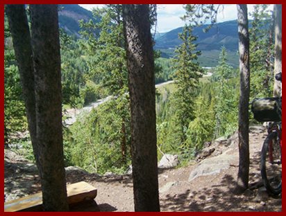
|
|
advertisement |
|
|
advertisement |