| |
| |
Snoqualmie Pass
Snoqualmie Pass is not just the I90
summit, zooming by the windshield between Seattle
and Washington. There are two interesting cycling
goals up here. The more popular one is also lower,
a tunnel through the top. It is on the Snoqualmie
Tunnel(sh) page. Snoqualmie Pass itself has enough
non interstate pavement over the top, that I have
to put it into the paved category. But in order to
connect it to the rest of the world on both sides
with a bicycle, you have to put up with some
unpaved roads.
After a few km the nice quiet forested highway
merges into the Interstate. The recorded route
follows I90 to the next exit, even if there is a
"no bicycles" sign at the entrance. These couple
of kms are the only part of the route that is on
I90.
After many kms of this quiet woods cycling
Tinkham Rd reaches the next I90 exit. Even though
it is possible to stay on this side of I90, the
route switches over onto the north side. There are
no signs here, but if you continue on the south
side the road eventually ends. Surprise - this side is paved, apparently for the campground traffic that is a couple of kms up Denny Creek Rd. The sign gives no hint, that this road actually goes through to the summit. Neither do the drivers on the road seem to know. They just drive to and from the campground. Apparently tourists here do not venture far from their Interstate highways.
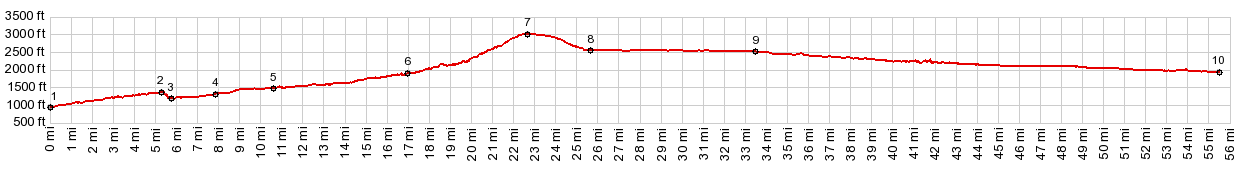
The highest point is in a collection of strip
mall businesses, gas stations and an expresso
stand, ugly and kitschy enough so that you might
expect a National Park entrance starts just on the
other side. From South. (described downwards). The
paved road descends just a little less than 500ft,
before it meets the East Summit exit. Another "no
bicycles" sign adorns the entrance to I90. But it
is easy enough to switch to the Hyak trailhead of
the Iron Horse Trail. Here an old railroad station
has been refunctionalized into a series of toilets
that stand in the middle of a large parking
lot. I have seen more attractive railroad
stations, but not more attractive toilets.
A Dayride with this point as highest summit: PARTIALLY PAVED / UNPAVED ( < Stampede
Pass | Steens
Mountain Loop Rd s(u) > ) Snoqualmie Pass : near intersection Iron
Horse Trail - Stampede Pass Rd > Iron Horse
Trail west > Snoqualmie Tunnel(shp) > Iron
Horse Trail west > Cedar Falls Trailhead >
Rattlesnake Lake > Cedar Falls Rd north > SE
North Bend Way west > Snoqualmie Valley Trail
in many directions > back to Rattlesnake Lake
> Iron Horse Trail east > unsigned dirt road
between Ragnar and Garcia north > Olallie State
Park > SE Homestead Valley Rd west > I90
west > Tinkham Rd west > Denny Creek Rd west
> Snoqualmie Pass > Snoqualmie Pass East
summit > Hyak > Iron Horse Trail east >
jct Iron Horse Trail - Stampede Pass Rd <>
out and back on Iron Horse Trail east as far as
next tunnel ~150ft lower than Snoqualmie
Tunnel(sh) : 78.0milesw with 3050ft of climbing in
6:31hrs (garmin etrex30: m5:17.8.30)
|
 At the next exit a quiet
dirt road, Tinkham road stays on the south side of
the Interstate for many kms. It has lots of holes,
but an easily bikable surface with any type of
road bike. It passes a campground and many
impromptu campsites. These are busy woods.
At the next exit a quiet
dirt road, Tinkham road stays on the south side of
the Interstate for many kms. It has lots of holes,
but an easily bikable surface with any type of
road bike. It passes a campground and many
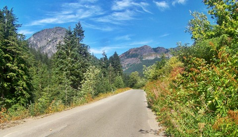
impromptu campsites. These are busy woods.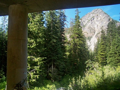 But this little paved
Denny Creek Road is actually a beautiful climb
through the woods, with twisting turns, all
confined between opposing lanes of the Interstate,
which are still at a comfortable distance. A
mountain or two can be seen poking through above
the trees. The profile again switches over on the
south side of I90 at the next exit "West Summit"
But this little paved
Denny Creek Road is actually a beautiful climb
through the woods, with twisting turns, all
confined between opposing lanes of the Interstate,
which are still at a comfortable distance. A
mountain or two can be seen poking through above
the trees. The profile again switches over on the
south side of I90 at the next exit "West Summit" 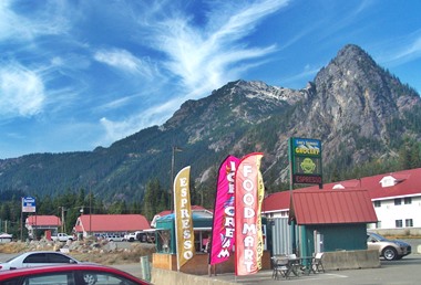 The Iron Horse trail
follows the quiet south side of Keechelus Lake,
but the noise from I90 on the other side from a
major road construction event still make it over
to this side. The approach is described further on
the
The Iron Horse trail
follows the quiet south side of Keechelus Lake,
but the noise from I90 on the other side from a
major road construction event still make it over
to this side. The approach is described further on
the |
|
advertisement |
|
|
advertisement |