| |
|
|
|
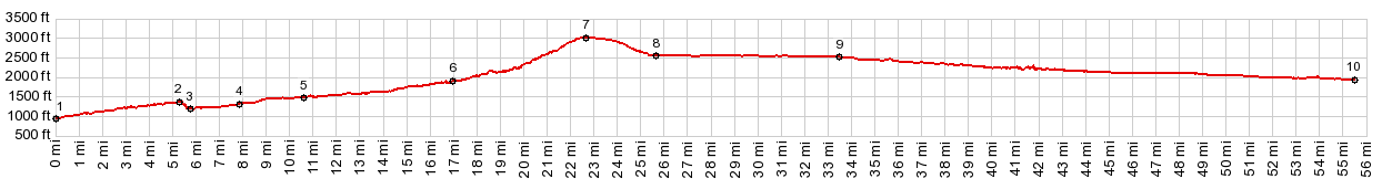
01.(00.0m,0940ft) START-END WEST: eastern trailhead for Iron Horse Trail
02.(05.3m,1390ft)profile leaves Iron Horse Trail and descends dirt road into valley
03.(05.7m,1200ft)route joins paved Homestead Valley Rd
04.(07.9m,1320ft)profile goes onto I90
05.(10.6m,1480ft)profile goes from I90 onto unpaved Tinkham Rd
06.(17.0m,1940ft)route changes from Tinkham Rd to Denny Creek Rd
07.(22.8m,3040ft)TOP:Snoqualmie Pass
08.(25.6m,2560ft)route joins Iron Horse Trail again.
09.(33.5m,2530ft)profile crosses Stampede Pass Rd
10.(55.5m,1950ft)START-END EAST: old Cle Elum station on Iron Horse Trail
|