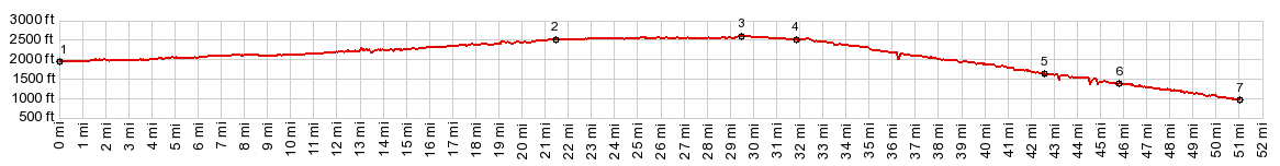
| |
| |
Snoqualmie Tunnel(sh)
aka Iron Horse Trail(sh) There are two interesting cycling
summits in the Snoqualmie Pass area. This is the
lower one, and also the more interesting. Its main
attraction is an unlit 2.2 mile long tunnel
through the top, and also a couple of bridges. The
Iron Horse Trail follows the old railbed of the
"Milwaukee Railroad"
But riding the trail today, it seems that the
next town is really the point of transition:
Easton. There is no perceived change in gradient,
flat is flat. But the forest becomes thicker, the
temperature drops dramatically when the sun from
here on is filtered through a thick canopy of
trees. It's time to put away the sun glasses. The
surface also improves for biking. The last miles
before getting to Easton are quite a chore, due to
a newly graveled road that has not been compressed
properly. Leaving Easton, the diminutive hills next to the
trail are replaced by the first far views of real
mountains: the high Cascades. They first appear as
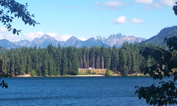
background to Lake Easton State Park just before
crossing the lake on a new trail bridge. Miles
later the first tunnel appears out of nowhere. If
you like this one - just wait for the summit.
Another interesting museum type informational
tablet in the wilderness talks about the silk
trains, that used to run from Seattle eastwards.
They had right of way over everything else
including people express trains, in order to
transport easily spoilable, and price unstable
silk to processing centers in silk trains, pulled
by bipolar electric engines. The nicest part of the trail on this side is - I
imagine - also is the nicest part, of what was the
rail journey in the glas covered "Superdome" car,
and that is the handful of miles along the south
side of Keechelus Lake just before the summit. The
busy interstae stays on the north side of the
lake, while the trail is away from all the noise,
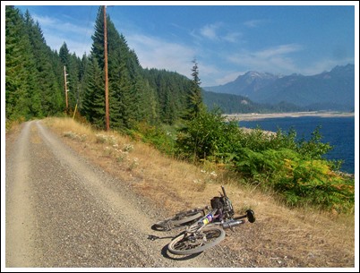
running along its southern shore. The lake has a strangely apocalyptic appearance,
because of the hundreds of tree stumps left on its
shore to accommodate high water - while right now
the lake seems almost empty. Even along the lake,
many times the trail dives into deep quiet forest
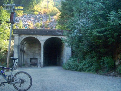
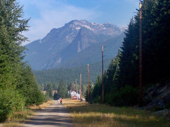
and a few Cascade Peaks loom above. The tunnel entrance is the highest point -
by just a few feet. It comes a short distance
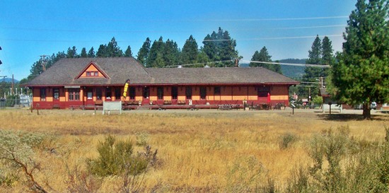
after the Hyak trailhead, Here an old
railstation has been refunctionalized into
multiple toilets - not the most beautiful railroad
station I have ever seen, but probably the most
"beautiful" set of toilets. There are no dire
warning signs about the impending prolonged
darkness when approaching this point - unusual for
a country where you are warned about every tiny
thing. Approaching the tunnel on a warm day, a
moist cold wind flows out of it like a river. For
those not in the mood for 2.25 miles of utter
darkness there is an option to climb a little
further to Snowqualmie
Pass and then find the descend down its west
side.
From West. (described
downwards). This is a well behaved tunnel, but it
is completely unlit and very long. It has a slight
bend, but as soon as you enter you can make out
the tiny dot of light on the other side. So there
is no danger of getting lost or tripping over
stuff, but instead of loosing things in the dark
and running into the tunnel walls - if you do not
carry a good light. I met one cyclist along the
way who prides himself in going through this
tunnel without a light, or at most with the
illumiation of a cell phone. But it is much more
fun with a light - I think. I met a total of 5
people in the tunnel, all hikers with tiny
flashlights that were hardly visible. 2.2 miles later the daylight returns in full
glory, and sheds onto a beautiful view of I90, far
below, marching up the valley on stilts. The
railtrail traverses along the hillside all the way
to Cedar Falls and looses elevation very gradually
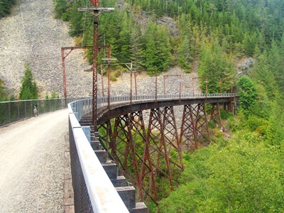
and steadily - as expected. Along the way the
fast, well surfaced dirt trail passes over two
high metal trestle bridges, and a handful of
smaller ones - also a reconstructed snow shed and
signs marking the old siding names. The connection to the rails is all in memory,
Signs along the way recall the history and the
trains, but there is nothing left except the grade
the trail is on. Instead several single track
trails give the handful of mountain bikers a
chance to explore the forested hills further. The
bikers with the panniers probably have other
things on their mind. After all this rail fantasizing, somehow I expect
to find a park of old historic engines at the
trailhead in Cedar Falls - after all it's
name is "Iron Horse State Park". But there is
nothing of that kind - just a lake in the woods.
The profile continues to descend further on a
connecting rail trail - the Snoqualmie Valley
Trail, which winds further down into the valley to
a low point near I90.
A Dayride with this point as shoulder point is on page: Snoqualmie Pass Historical Notes: The Chicago, Milwaukee and St Paul Railroad started operation on this line in 1881. In the coming decades the "St Paul" mutated to "Puget Sound" and then "St Paul and Pacific". Maybe that is the reason that this railroad is generally known by the geographically more general part of its name the "Milwaukee Road" Passenger service on this western extension railline began in 1910, a year after it was completed. Trains operated between Chicago and Puget Sound and were electrifed with bi-polar motors starting in 1920. Old photographs of the most popular trainset of the railroad profilferate: the streamlined Olympia Hiawathan. It started running just after WW2 in 1947. Curiousely this was a diesel train on this the most electrified of all American railroads. It took 45 hours between Chicago and Seattle.
However business was not going as good, as the flashy train might inidcate. The 23 million dollars that the western extension cost was three times the original estimate. There was also more competition, not so much from other railroads, but from the Panama Canal for the overland traffic and also from the automobile. The decline was long and painful. First reorganized in 1927, the company went bankrupt anyway, in 1935. Reorganized encore lead to final bankruptcy in 1977, with the remains sold and buried in 1985. The bike trail, also named after a non biking old movie star of bad cliche Hollywood westerns (think the name is John Wayne), was opened in 1985 |
|
|
advertisement |
|
|
advertisement |