I feel a little torn about this
one. This dirt road goes over some of the most
unusual and incredible scenery in Oregon and the
western US. There is hardly any traffic. But it
also involves, what must be the worst washboard
surface anywhere. In a civilized world this
would be a paved road. But then again - the
civilized world is over 70 miles distant from
the summit, assuming you want to attach any kind
of label, let alone this one, to the pleasant
agricultural town Burns. .... and looking on the
bright side, having a mountain range above a
shining white salt dessert to yourself for the
ride, does have its own appeal. I met one other
cyclist on this route - a great proponent and
enthusiast of biking this road, also working as
campground caretaker together with his wife in
the area.
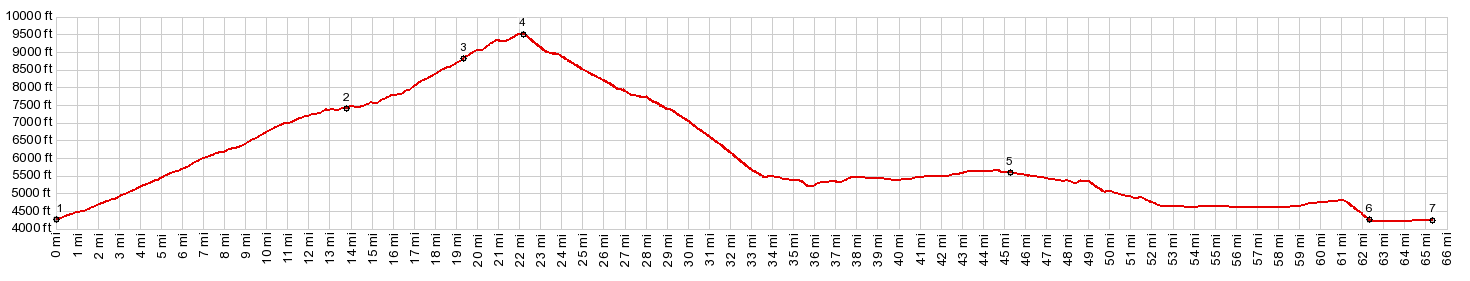
Just south of there a dirt road with a prominent
BLM sign, marked Steens Mtn Rd and Fish Lake Rd
turns off to the south, and descends a little on a
slightly inclined plane, in order to cross Donner
and Blitzen River. And that is actually where the
profile starts. There is also a pay BLM campground
without water, hiding in the crack of a thick
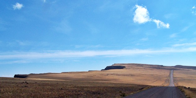
layer of lava or basalt here. The road starts to climb gently and I keep a
lookout for Steens Mtn. But I don't see it, and
suspect that it is hidden in the haze somewhere.
After returning to this spot after the ride, I now
know, that Steens Mountain from this location is
the almost unrecognizable lip of rock, barely
rising above the horizon in the distance. Maybe it
is good thing, that I did not know, because the
oppressing September heat and the extreme
washboard surface make progress slow, and there is
not that much to look at.
After several miles of variably steep climbing
the road reaches another BLM fee campground. This
one is grouped around peaceful Fish Lake. If
you just stay at the shore of the lake, you get
the impression, that it could be also located in
Wisconsin somewhere. That's how planar the scenery
appears to be. Wrong impression ! The road just
keeps climbing over gentle waves of grass-scape. Suddenly it becomes apparent that the road runs
along the rim of a plateau, that falls off with
perfectly vertical walls onto a deep and stark, U
shaped canyon. All the viewpoints are located a short distance
away from the loop road, and require a little
additional climbing that is not included in the
profile. The first one of these over Kiger Gorge
includes something special to look at, for this
plateau range: a sharp ridge. Glaciers on both
sides carved almost vertical walls, and their tops
meet for a short distance, before the range
resumes its plateau character on both sides. It soon becomes apparent that the road follows
this strip of a plateau around the head of a
canyon. The canyon itself is a perfectly U shaped
gigantic raingutter, the canyon carved by Little
Blitzen River. The little refers to the river,
which is nowhere to be seen on this dry September
day. The top of the loop road is located at the
intersection with the short access road to East
Rim Viewpoint. At this intersection another road
branches off to the plainly visible transmission
facility. It is labeled as Steens Summit. The last
part of the Steens Summit out and back route is a
foot trail that was previously also used by small
motor vehicles. The highest point is only about
200ft higher than the loop road summit. But the
view is quite different, because it includes the
canyons falling off to the south. Nestled between
the canyons on the south side likes an almost
unbelievably big lake for such a dessert range:
Wildhorse Lake. Back to the loop road: access to the East Rim
viewpoint is much shorter, just a couple of
hundred yard. Below lies a white plain floating in
the haze, the Alvord dessert. The range falls off
in craggy ridgelines with barely any vegetation cLiCk on image ,
arrows , or thumbnails to advance
slideshow From North-2: (described
downwards). For the first several kms of the
descend the road builders picked, what must surely
be the most spectacular location for a road in the
Steens canyons. The road runs on a roughly half km
wide erosional surface between Little Blitzen
Gorge and Big Indian Creek Gorge. Even after
taking in the many dazzling views along the
plateau, the last one is a kind of extreme example
of this vertical block landscape. Finally the erosional surface ends and on the
west side the road manages to find gentler slopes
to descend, but not before one last traverse along
the high plateau presents and a plethora of views
showing off Big Indian Creek Gorge like a bowling
alley. At the bottom of this set of switchbacks the road
passes South Steens campground, the only point
along the road where water is available. Past this
point the already extreme washboard character of
the road becomes even more extreme -and worse the
road starts climbing again gently. The good side
of this is, that after the small climb you
actually get some descend views of the Steens Mtns
from a distance. This really is one range where
the designation plateau and range would fit
equally. It is shaped like a cubistic impression
of a coffin. This second section of the ride back to Or205 is easily underestimated, when looking at the route on the map. Finally 8 miles of sweetly paved road lead north back to the Frenchglenn Hotel. One of the biggest surprises of the loop comes before reaching it. After endless miles of straight road, or at least spotting parts of the road in the distance half an hour before reaching it, Or205 suddenly turns right and descends unexpectedly for at a grade of 12 to 14 percent. The view during the descend is the vast inclined alluvial plane, leading up towards the Steens mountains. It is so vast and shallow, that it is disorienting from a bike with screeching brakepads. The profile continues down the northern Steens Mtn Rd to the low point where the profile starts. cLiCk on image ,
arrows , or thumbnails to advance
slideshow |
|
|
advertisement |
|
|
advertisement |