| |
| |
Stampede Pass
Stampede Pass runs roughly parallel
to Snowqualmie Pass and its bike trail. On the map
it looks like it would be a great unpaved day
loop. But - as is often the case, the forest
service does not approve of this. The road is
closed on the west side. The only consolation is,
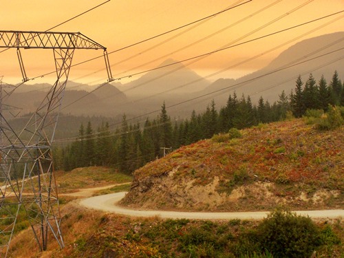
that this is an ugly and uninteresting area,
during my visit made even more so by a thick
blanket of acrid smoke from forest fires.
There is a signed junction with a road to Tacoma
Pass. The sign warns of a dead end and no
connection to the valley in Easton. Yet another
road the forest service does not approve of.
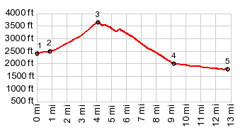
From West. (described
downwards) More switchbacks under the powerlines.
Before the road is closed there are two junctions
with other major forest roads, one right and one
left. According to the map they do not offer a
possibility to connect to Cedar Falls for a loop
ride. Soon after that the barriers and "closed road -
walk in access only" signs appear, specifically
prohibiting bicycling in the area. As is the
custom in the US (and only in the US, as far
as I know) cyclists are lumped in with their
"brethren" the motorcycle and ATV warriors. The
profile ends at the road closure, even though
there is much more elevation loss to be had. In a
more interesting area I would be tempted to try to
explore this route anyway. But here - who really
cares ?
Dayride with this point as highest summit: PARTIALLY PAVED / UNPAVED: ( < Rat
Trap Pass | Snowqualmie
Pass > ) Stampede Pass x2 , additional out and back :
near jct Stampede Pass Rd - Snowqualmie Pass Trail
<> up Stampede Pass Rd <> down west
side of Stampede Pass rd << turaround
point at road closure west of jct FR54-FR52
|
 The summit of Stampede
Pass is in the forest without sign or views. But
maybe that's a good thing. This way you don't see
all the destruction caused by large scale
commercial logging. One logging road leaves from
the summit.
The summit of Stampede
Pass is in the forest without sign or views. But
maybe that's a good thing. This way you don't see
all the destruction caused by large scale
commercial logging. One logging road leaves from
the summit.|
|
advertisement |
|
|
advertisement |