| |
| |
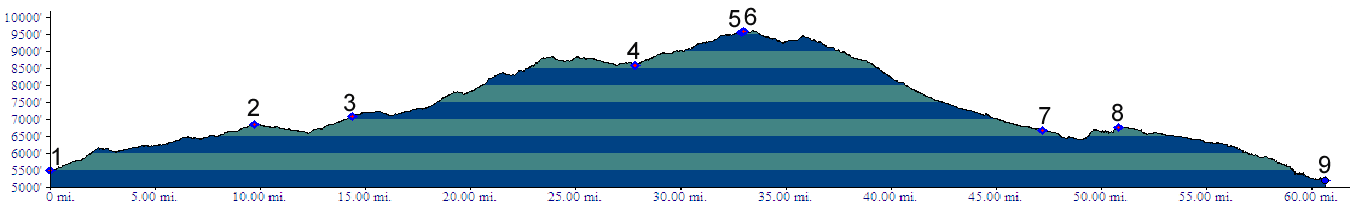
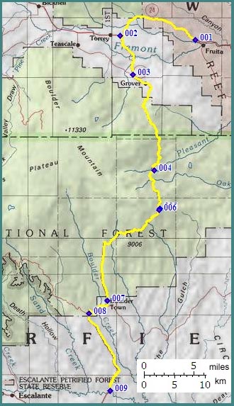
Ut12 summit: Boulder - Capitol
Reef If there is such a thing as a single quintessential bicycle touring route through southern Utah, it is Ut12 in conjunction with a small part of Ut24. This summit is the highest point on the route. The panoramas seen from this route, stretch over vast distances from Navajo Mountain in Arizona to the exposed magma of the La Sal and Henry Mountains in eastern Utah. But crisp, clear autumn weather is necessary to really see them. But the main attractions are not even near the summit. Instead the variety of canyon scenery on the lower approaches are the most unique characteristics of this route. Ut12 is not the only way to get to the summit. A wide variety of long hilly approaches, traversing canyon country of different characters, lead to the summit. In addition to the three approaches mentioned in this page, the Burr Trail ( which is a dirt road ) also terminates in Boulder, which is located on the profile below. Since there is more than a 300 feet rise between Boulder and the summit on the Burr Trail, it gets its own page.
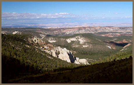
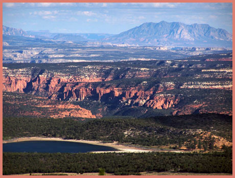
From East. The Waterpocket Fold ( Capitol Reef National Monument ) is famous for being breached by many narrow slot canyons, which show river courses that existed already prior to the uplift of the Colorado Plateau. But Capitol Reef is also breeched by a larger flat bottomed canyon, from which walls of varying heights rise abruptly. This is the valley of the Fremont River and also today's Ut24. Starting in the east, the road travels through increasingly older rocks, the most noticeable being the white Navajo Sandstone, contrasting the later red rock formations like the Morrison formation. As the route turns onto Ut12, a number of overprized gas station strip mall complexes line the road. Torrey is slightly off route, but also much more attractive with a large shadow spending arcade of trees lining the road. Fortunately the 1 mile detour does not hurt. The Ut12 portion of the climb begins reluctantly after a 90 degree south and a flat section. Then the road climbs into dense forest, flattening out periodically, and opening windows onto the Upper Blue Hills and Henry Mountains. Compared with other Utah landscapes, the mountain traversed by this route, Boulder Mountain, is a rather shapeless affair, a large bread loaf, but a loaf with a thick German bakery style crust, a thick black caprock - or white if there is snow on it. It can be seen periodically above the upwards curving road. By the time you reach the summit, you are on eye level with the more strongly eroded Henry Mountains. The highest peak there is the 10723ft Mount Hillers. The top of the road contains a summit sign with home made appearance, stating an elevation of 9400ft. However the topo map labels the same spot with 9591ft. A short dirt path east leads to several new panoramas, stretching south from Navajo Mountain in Arizona to the La Sal Mountains behind the Henrys and the Circle Cliffs below.
From South. The most interesting canyon
area is the first part of the profile, the Navajo
sandstone slickrock slopes around the Escalante
River and its side canyons. After crossing the
river the road climbs a ridge in a way that
complements the landscape, courtesy of a Civilian
Conservation Corps built road. The ridge road ends
in Boulder and continues on a gently sloping
forested plain. Boulder has a minimum of
provisions that can be relied on without
reservations. The slope picks up gradually leaving
Boulder, then leads to the summit in a large sweep
above treeline. Two overlooks are along the way.
Alternate Approaches From South: Using a mountain bike you can also approach the summit via South Draw Road in Capitol Reef National Monument. The description begins at the south end of the Slickrock Divide, more commonly known as the scenic drive in the monument, also the location of the Capitol Gorge trailhead. A good dirt road climbs over a small saddle to a historic ranch. After a stream crossing the road follows the dry South Draw and slowly curves northwards. After leaving the stream bed the path becomes quite rocky and crests at a spot that could be considered as a separate summit, if there were an additional way to approach it. This is a good vantage point onto the reef. But the Henry Mountains can be glimpsed only through the middle of a saddle in the reef. The route descends into a valley, each side a different color, later crosses a small stream running in a verdant green pasture, then climbs on intermittently rocky surface to what must be one of the world's most scenic cattle corrals. (There is a photo on the picture page). From here on the surface is smooth, but the grade picks up considerably. The elevation begins to exceed the top of the reef and the Henry take their place as the eastern backdrop. The dirt road joins Ut12 at a level spot. Turing right makes a nice loop in its own right. Turning left continues to the summit. Dayrides. A loop ride beginning in the Torrey area, going over the FR154 summit: Posey Lake Road continuing over Hell's Backbone Road summit(u) to Boulder, returning to the starting point via Ut12 summit: Boulder - Capitol Reef measured 114 mikes with 11510ft of climbing in 10:5 hours. This includes about 5 miles and 500ft climbing used to access the loop (m3:06.09.23).
|
 Principal
Approaches
Principal
Approaches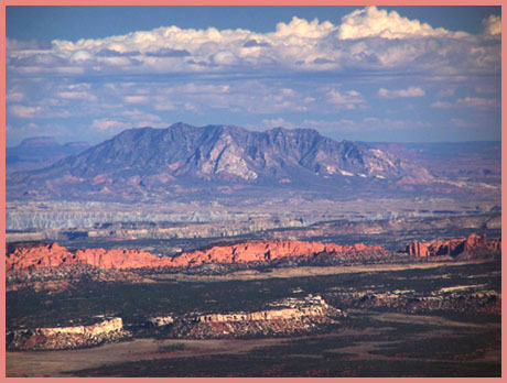
|
|
advertisement |
|
|
advertisement |