| |
| |
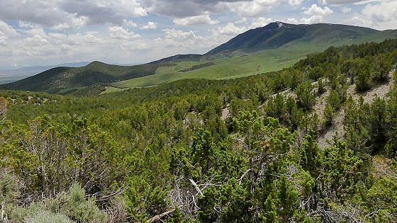
Fisher Pass Fisher Pass was on the first
designated Overland automobile route - the
Lincoln Highway, and in places the area seems as
wild and isolated as it must have been seen back
then. But today Fisher Pass also fills another
role. It is a sort of commuter route between the
Salt Lake area and Dugway, the settlement that
constitutes the human infrastructure necessary
to maintain the Dugway Proving Grounds of the US
Army. It may come as a surprise for such
an isolated area. But this road is immaculately
paved and crosses the edge of a range climaxing
in a 10 thousand foot mountain on one side,
Deseret Peak in the Stansbury Mountains. On the
other side are the somewhat lower forested
Onaqui Mountains.
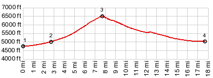
From West. Leaving
the security controlled entrance of Dugway, Ut199
is as straight as a ruler. The profile starts at a
low point in the valley a few miles out of Dugway.
But I never took note of the actual low point
because I was too busy watching the clouds form
over Deseret Peak (11031ft) This is the more
attractive side of the range. Looking ahead up the
way into the mountains, the road seems to make
just one little jog to the north, before again
resuming its straight line - as if somebody had
made a mistake with the theodolite and placed the
road just a wee bit too far to the south. But
actually before the road gets to that point it
passes a collection of houses named Terra on the
map. While on the left side a sign reads "Welcome
to Terra" a sign on the right reads "First Street,
no trespassing". No need - nothing much here, no
people no businesses, no picturesque decay.  Just before entering Terra an
important junction marks the place where the Old
Lincoln Highway joins Ut199 (when heading east).
On the west side of this point the road signed
"Lincoln Highway" angles just a bit more to the
north. Even though there is practically zero
traffic on it, it is even paved. Another road at
this junction heading south is a shorter
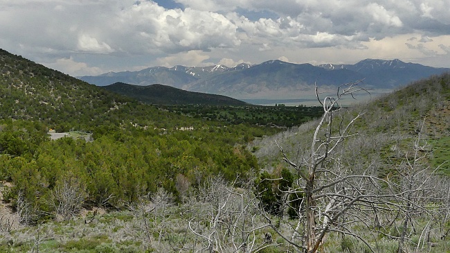
connection to Lookout Pass. Past Terra the road enters a
surprisingly curvy ravine with an equally
surprisingly steep climb to the top, traversing
juniper forest, but breaking out above it at the
pass. From East (described
downwards). At the top stands a sign with an
elaborate explanation for the name of the pass,
which I will save for the history section below.
An elaborate descent on wide radius curves leads
to a large collection of houses, spread out over a
large area. I would call it a village or town. But
that would imply that there are also some kind of
businesses or sevices there, and I did not see
any.
History
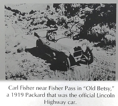 Modern Highways. The
first cross country automobile route was created
in 1919 by Carl Fisher. Going through Wyoming the
route followed the course of today's I80 and never
crossed anything resembling a mountain road or a
pass. Enter Utah and there was the decent into
Salt Lake Valley, and then came this pass. It was
not named after Mister Fisher at the time. The
sign at the top seems to have been put up in 2008.
Both my DeLorme Atlas and my OpenStreetMap on the
computer name this pass Johnson Pass. Modern Highways. The
first cross country automobile route was created
in 1919 by Carl Fisher. Going through Wyoming the
route followed the course of today's I80 and never
crossed anything resembling a mountain road or a
pass. Enter Utah and there was the decent into
Salt Lake Valley, and then came this pass. It was
not named after Mister Fisher at the time. The
sign at the top seems to have been put up in 2008.
Both my DeLorme Atlas and my OpenStreetMap on the
computer name this pass Johnson Pass. Continuing into Nevada, the Lincoln Highway did entertain a few more named summits along today's US50, the barely noticable (as far as elevation is concerned only) Hickison Summit, and then Austin Summit and for a while Carroll Summit Dayrides with this point as highest summit: PARTIALLY PAVED / UNPAVED ( < Leppy Pass | CR180 Evanston Rd microwave tower s(u) > ) Fisher Pass , Lookout Pass: near jct Ut36 - Faust Rd > Ut36 south > Pony Express Rd west > Lookout Pass > unmarked gravel rd heading west from Pony Express Rd > Government Creek Rd north > Dugway entrance > Ut119 east > Fisher Pass > Ut36 south > back to starting point near jct Ut36 - Faust Rd 58.3miles with 3040ft of climbing in 5:21hrs (garmin etrex32x m5:23.6.8) (pics t23_13_28-51 t23_14_1-12) Notes: fantastic weather with cool clouds in the afternoon, while the east US is experiencing smoke from Canadian wildfires. ( < Silver Island Mtns unn-1 s(u) | > ) Fisher Pass : Lone Rock BLM area > Skull Valley Rd south > Old Lincoln Highway north > Ut199 east > Fisher Pass > Ut36 north > Meadow Ln west > Main St north > Mormon Trail north[this is a road] > Grantsville > Ut138 west > Ellerbeck Rd west > TC3230 west[unp] > Skull Valley Rd south back to starting piont in Lone Rock BLM area 90.2miles with 3360ft of climbing in 7:05hrs (garmin etrex32x r4:23.11.3) Notes: unpaved section is extremely short ( less than 2 miles), and can be avoided by switching to I80, though this may involve crossing lanes of traffic - a perfect weather day in every way in November - the climb on Mormon Trail[pvd] does apparently not permit a 500ft climb on the south side. So I am not counting it as a summit, even though the climb on this route was more than 300ft. |
|
|
advertisement |
|
|
advertisement |