| |
| |
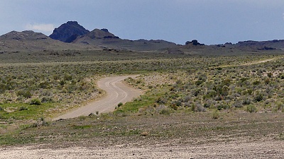
Leppy Pass I'm really glad this one is just a bit higher than the 500ft minimum elevation gain. That's a cutoff point I have set, as a minimum requirement to include a point in these pages. Regardless of what I need, this point will always be a popular gravel biking destination for Salt Lakers, even if the destination signs mentions autos and not bicycles: the "Silver Island Mountains Auto Backroad Byway". This point is just a small part of this loop, even if it is the highest. This point is on the south side of the loop. The highest point on the north side of this loop is barely 200ft above the sea level. But historically the northern high point is the most interesting. A sign reminds of the Hastings Cutoff and the history of the Donner - Reed party, a tragic California immigrant story. Leppy Pass actually crosses the
Silver Island Mountains between Leppy Peak and
the rest of the range, which gradually increases
in height towards the south and then fades away
to nothing where it crosses Donner Reed Pass. I
think one reason this is a popular bike loop, is
because of the generally very bike friendly
surface. However, I rode this a few days after
heavy rain, creating probably the best surface
conditions compared to other weather conditions.
 The really noticeable part of the
climb does not start until the road passes a sign
to Silver Lake Island Pass. That point also does
not offer the minimum 500ft of climbing to be
included in these pages. Leppy Pass climbs slowly
and deliberately, and in my case under the burning
sun. There are many turnoffs that look like they
might offer other routes across this rocky carpet
of fanciful mountains, even if the map does not
confirm this possibility. The really noticeable part of the
climb does not start until the road passes a sign
to Silver Lake Island Pass. That point also does
not offer the minimum 500ft of climbing to be
included in these pages. Leppy Pass climbs slowly
and deliberately, and in my case under the burning
sun. There are many turnoffs that look like they
might offer other routes across this rocky carpet
of fanciful mountains, even if the map does not
confirm this possibility.By now the road is far from the sand of the lake, but barely any higher when compared to the benchmark, the 10 thousand foot high Pilot Range, across the playa in Nevada. At the top of the gentle Leppy Pass is a sign. But it says nothing about the pass. Instead it warns that the nearby pile of gravel is for use of the Utah Department of Transportation, and that carrying away of this gravel is definitely punishable by the law. So go collect your rocks somwhere else. ... and surprise, there is pavement up here. At virtually the same elevation, two directions of pavement continue downhill, one direction east from where this loop started, the other heading northwest, direction just between the Pilot Range and Wendover. From East. (described
downwards) A short paved roll leads down towards a
gentle gap between rounded desert aunthill
landforms, dotted with desert grasses like a
regular pattern of freckles. The remaining
triangle behind the gap is a regular pattern of
strong contrast horizontal lines, representing
various shore line salt levels of the Newfoundland
evaporation basin. A single modern home with
4-or-more car garage, and storage sheds the size
of airplane hangers completes the incongruous
landscape. The profile continues on a short rustic
paved road towards I80 until it reaches a low
point.
Dayride with this point as
highest summit:
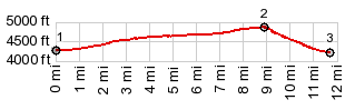
PARTIALLY PAVED / UNPAVED ( < Angel Lake s(u) | Fisher Pass > ) Leppy Pass: closest point to I80 of Silver Island Mtns Loop : Silver Island Mtns Loop counterclockwise > Donner/Reed Pass(shp)/Hastings Cutoff > Leppy Pass > back to starting point near I80: 54.4miles with 1680ft of climbing in 5:06hrs (garmin etrex32 m5:23.6.5) Notes: the paved distance is only a couple of miles - comfortable morning, hot afternoon. There are quite a few people camping in RVs near the beginning of the loop (let's say winthin 5 miles). But surprisingly I encountered no other vehicles or people of any genre on the rest of the loop. |
|
|
advertisement |
|
|
advertisement |