| |
| |
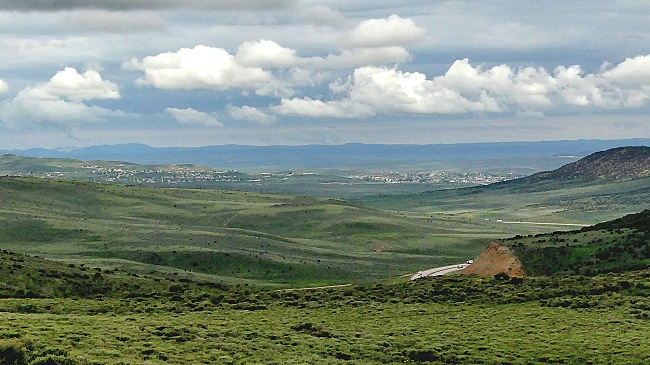
CR180 Evanston Road
microwave tower s(u)
I went looking for historically
famous Wahsatch Pass west of Evanston, and
couldn't fine it. Instead I found this little
summit on my circuitous approach east of Evanston.
But there is no climbing approach to here from
Evanston. You can get here, you just can't climb
here. It is at virtually the same elevation. But
there is a point sufficiently low between the two
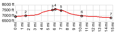
for the profile below. These are the topographic
peculiarities of western Wyoming.
From South.
(described downwards) A short track leads down
to an I80 entrance. The profile continues on the
spacious shoulder of I80, Of course you could just
go back down to the petroleum tanks and decent on
the same road, in the opposite direction, towards
the west. In either case, if you want to connect
to Evanston, a few miles on the shoulder of I80
are inevitable. It is much safer than most two
lane roads. The shoulder is is wider too.
A sign labels the exit, where the "petroleum tanks" road connects as "Painter Rd". However, consulting the map, that name refers to a road on the opposite side of the Interstate exit. It is actually closed off by a locked gate, and there are no further signs here. The wide paved road on the south side of the Interstate is named CR180 Evanston Rd (prevriousely referred to as :petroleum tanks rd"). Dayride with this point as highest summit PARTIALLY PAVED / UNPAVED
( < Fisher Pass | CR173 Piedmont Rd s(u) > ) CR180 Evanston Rd microwave tower s(u) , CR180 Evanston Rd(sh) : jct US289 - I80 > CR181 following Abert Creek south > CR180 Evanston Rd(shp) > CR180 Evanston Rd microwave tower s(u) > jct I80 - Divide Rd > I80 west > Evanston <> out and back from west end of Bear River Trail to east end of Bear River Trail > several sightseeing miles around Evanston <> out and back on Washatch Rd along I80 towards Wahsatch << turnaround point a few miles past Ut - Wy line >> Evanston > I80 east > Evanston Rd east > Evanstyon Rd(sh) > back to starting point at jct US289 - I80 <> separate out and back a couple of miles on US289 north : 59.6miles with 2370ft of climbing in 5:51hrs (garmin etrex32 m5:23.6.13) |
|
|
advertisement |
|
|
advertisement |