| |
| |
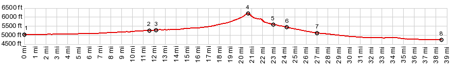
Lookout Pass The western desert ranges of Utah
have many wide gaps. So the elevation gains on
these passes often stays within limits. This is
actually one of the larger climbs, compared with
the points west of here.Because of a number of
unusual surprises along this route, I have to
make this one one of my favorite passes in this
general area.
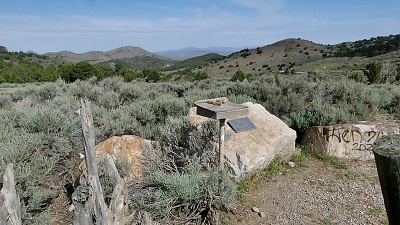
A straight, fast smooth dirt road leads up to a low gap on a wooded ridge between the Simpson Mountains and the Onaqui Mountains. It leads to a an attractive, well defined summit. This spot has a very cared-for appearance, with a very pleasant view onto the desert ranges to the west. The cared-for appearance is due to a picnic table, a nicely constructed wooden fence and a plaque, telling the role of this pass as a sheep herding driveway, from a long time ago and still used for that purpose. The plaque is in honor of a sheep person active in this field.
Soon after this the profile takes
the right option at a fork, and deviates from the
marked Pony Express route. The route here becomes
a little rougher, but I would still call it
bicycle friendly. Taking a right at the next T
junction leads onto Government Creek Rd heading
north towards Dugway. These names are from maps.
None of the junctions are signed. 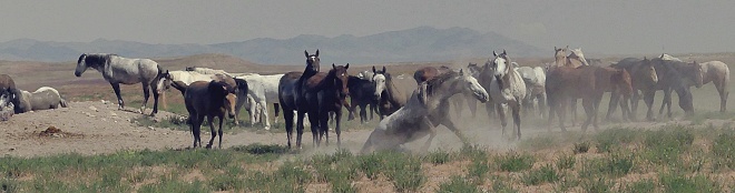 The next surprise on this unusual
route is a main watering hole of the Tonaqui Wild
Horse management area. There must have been about
100 horses there living out there, putting their
social interactions on display, while a handfull
of telephoto lens equiped tourists were watching
not far away. A sign later along the route
explains that this large number of 100 to 200 wild
horses in a single clan is not at all the norm,
but due to the way the horses are managed by the
BLM. Several families band together with a single
lead horse and mare, also a harem of sorts, while
younger males leave the family and band together
in expelled adolescent groups ... that is (I
guess) a kind of ghetto horse neighboorhood with
gangs. One more surprise waits along the
route before reaching a low point. The road seems
to be approaching a healthily sized village with
all kinds of businesses and interesting
institutions. Once on pavement, the entrance turns
out to be a guardstation with no entrance
permitted. Good thing I have some water left.
These are the Dugway Proving grounds. The profile continues back in an
easterly direction towards Fisher Pass
until reaching a low point on Ut189 and adjoins
the Fisher Pass profile.
|
 From West.
(described downwards). This attractive summit is
only the first of several surprises along the
route. After starting a fast decent, the next
stone column marks the site of the Lookout Pass
Pony Express Station, while meanwhile on the other
site of the road a pet cemetery will keep those
occupied with less of an interest in this historic
horse torture institution.
From West.
(described downwards). This attractive summit is
only the first of several surprises along the
route. After starting a fast decent, the next
stone column marks the site of the Lookout Pass
Pony Express Station, while meanwhile on the other
site of the road a pet cemetery will keep those
occupied with less of an interest in this historic
horse torture institution.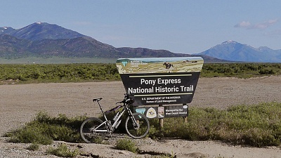
|
|
advertisement |
|
|
advertisement |