| |
| |
FR221 Sheep Creek - Long
Park(sh)
FR221 runs along peaks of the
eastern Uinta mountains, surrounded by meadows and
parks and gentle grades. It us higher than paved
Ut44 to Manila, but it still remains quite a
distance below the ridge
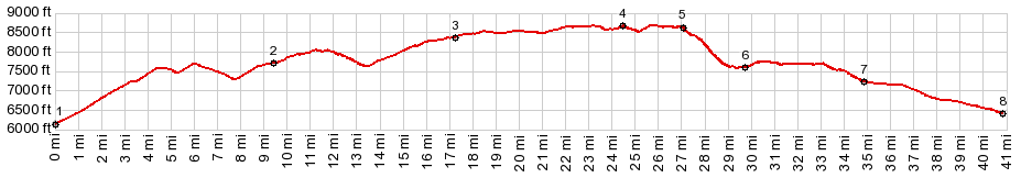
The profile starts at a low point, a short
distance east of the junction: Ut44 - Sheep Creek Canyon.
Both Ut44 and Sheep Creek Canyon are options to
approach Uinta Pass,
Ut44 does so with wide sweeping turns and views
onto Flaming Gorge, and Sheep Creek Canyon
accomplishes this with a much smaller road through
interesting rock formations. The profile follows Ut44. While climbing in the heat the wide road cuts far above can look intimidating. As the road approaches the forested zone it levels out and meets the upper access road to Sheep Creek Canyon. The recorded route continues on Ut44. The next big wave in the profile (on Ut44) is more than 300ft tall, but it cant be made into a 500ft approach. So I am not counting it as a separate summit. Soon the jct with Deep Creek Rd and its campground appears along the forested road The profile turnns onto Deep Creek Rd. It largely
stays in the forest. Near the beginning of FR221
an out and back on FR5 leads to a fire lookout.
Unfortunately it is not accessible, and there are
no real views from the bottom. But later along
FR221, the road runs along expansive sub alpine
meadows and wetlands, with an ever so gently
rounded chain of snow capped mountains behind it.
These wild flower strewn meadows are the best part
of the ride and many are signed: Half Moon Park,
Sheep Creek Park and others. FR221 gently climbs
to higher points (such as FR221 Uinta
Mtns(sh) ). But this route reaches its high
point at the turnoff to FR14 Long Park Reservoir 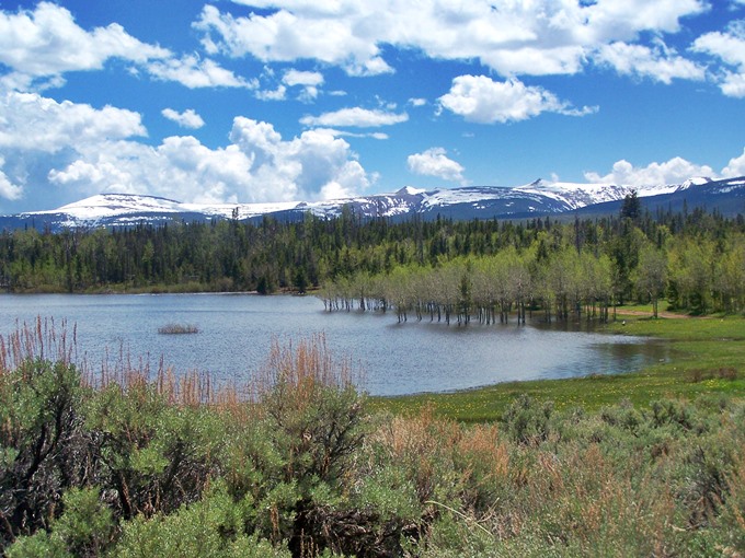 From West. (described
downwards) The road traverses points that are
practically the same elevation as the summit. Long
Park Reservoir is drowning its grasses and aspen
trees in blue snow melt water. It makes a
beautiful foreground for the chain of big white
lumps behind it. The route crosses a gate, then a small damn and
descends on a rocky rarely used road down the
Sheep Creek Canal. The water runs underground in a
pipe, leaving the stream bed dry. However vents
along the way give off loud hissing sounds - a
strange combination of being along a kind of canal
wilderness. In order to return to Ut44 the profile makes
several confusing changes in direction in order to
negotiate the Uinta foothill canyons. But the
profile always follows the most used route. Along
this part of the route it is easy to forget, that
this is still part of Utah. It looks much more
typical of nearby Wyoming. The last part of the
descent is a long, straight and gentle roll into
Manila. The most exciting part about Manila is the
fake paper mache deer next to the only motel in
town. Dayride with this point as highest summit: ( < Harper's
Corner Rd via Echo Park Rd s(u) | FR221 Uinta Mtns
s(u) > ) FR221 Sheep Creek - Long Park(sh) ,
Ut44 Manila - Sheep Creek s(u) : a
short distance up FR539 Deep Creek Rd > FR539
west > FR221 west <> out and back to end
of FR5 Ute Mtn Fire lookout >> FR221 west
> Half Moon Park > Sheep Creek Park >
FR221 Sheep Creek - Long Park(sh) > FR14 north
> Long Park Reservoir > across dam > down
road following Sheep Creek Canal > D1A rd west
> Connor Basin Rd east > Ut43 east >
Manila > Ut44 south > Ut44 Manila - Sheep
Creek s(u) > back to starting point on FR539
Deep Creek Rd: 52.0miles with 5400ft of climbing
in 5:44hrs (garmin etrex30: m5:17.06.02)
|
|
|
advertisement |
|
|
advertisement |