| |
| |
Harper's Corner Road the paved Harper's Corner Road
goes to to a magnificent view point above the
confluence of the Green and Yampa rivers in
Dinosaur National Monument. It descends less
than 500ft to the Harper's Corner panorama. So
it is just a one way summit. But combined with
the Echo Park dirt road it becomes a two way
summit.
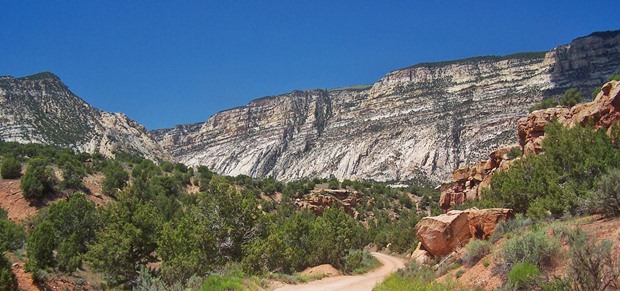
After these two routes have combined, the first
view is of Cliff Ridge and Blue Mountain, a sharp
escarpment that is actually accessible from this
road. After this initial view and climb the road
leaves the edge of the plateau, but that does not
mean it stops climbing, It rolls along in waves
and they add up to quite a workout. It is
virtually impossible to tell without measuring it
or looking it up, where the highest point on this
roller coaster is. It is on one of those bumps in
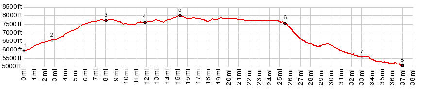
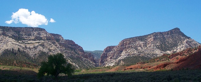
the road, while still in Colorado From North. (also described upwards) The climb on this side starts from the end of an out and back unpaved road: the Echo Park Road. Echo Park is the lowest point on the profile, and also by far the most interesting and scenically overwhelming. The confluence of the Yampa and Green is visible, but not immediately apparent. Rocks rise skywards in all directions. The confluence is located behind a shallow sandy island, visible at some distance between the cliffs. The island is often used as stopping area by rafters A BLM campground at the end point of the profile charges 10 dollars for camping and has water. But the most serene spot is a large grassy area along the river, a model of a park. The ranger has his house here. The trail along the river prohibits bicycling. But it is the ideal picnic lunch stop. From North-2. Following the paved road to its end at the Harper's Corner area, and including the foot trail to its lowest point just barely gets the required 500ft (510ft to be exact) to count this as an approach too. The road contains so much up and down that it seems to require about the same amount of energy in each direction. In whichever direction you choose to include all the viewpoints will be the more memorable one.
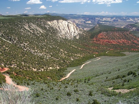
But eventually the time has come to ride back out
of Echo Park. The first part is short straight
shoebox type of a canyon. The next geologic layer
above is the lowest bench forming formation and
the landscape opens up a bit. The house of an old
pioneer settler is right next to the road. The
road meets the Yampa bench road and then enters a
sandstone canyon. The upper layer above is Navajo
sandstone, which erodes with massive crossbedding
into rounded exfolaliated domes. Climbing above
this formation, the road rolls along an upper
bench. These could be regular hills but there are
more shoebox cliffs above. The last climb out
happens on steep switchbacks. Turning south on the paved road, it leaves the
rim quickly. It passes what certainly looks and
feels like a summit point, where the viewshed
changes to the south, and many of the northern
canyon adjoining hills slip out of view. There is
even a very large cairn located on a hilltop
adjacent to the road - as if someone meant to mark
this spot as a summit. But the profile shows that
the actual high point comes later, after crossing
into Colorado. There is one more worthwhile detour before
getting there, a short out and back to the
Escalante Overlook, the perfect vantage point on
the just completed climb. It is best in late
light. After that the point of highest elevation
easily evades all notice, while it is crossed. Dayride with this point as highest summit: PARTIALLY PAVED / UNPAVED ( < Four A
Ridge Rd s(u) | FR221
- Sheep Creek-Long Park(sh) > ) Harper's Corner Rd: out and back: a short
distance below jct CR161-Harper's Corner Rd on
CR161 <> Haper's Corner Rd north <>
Harper's Corner Rd s(u) > down Echo Park Rd
<< turn around point at Echo Park with a few
additonal out and backs to viewpoints etc:
74.2miles with 6460ft of climbing in 7:34hrs
(garmin etrex30: m5:17.5.30). ( < Deer
Valley Rd via CR157(sh) | Harper's
Corner Rd via CR14 Miner's Draw RSd > ) same summit point: a short distance below
jct CR161-Harper's Corner Rd on CR161 <>
Haper's Corner Rd north <> Harper's Corner
Rd s(u) << turnaround point end of Harper's
Corner Trail: 63.7miles with 4970ft of climbing in
6:25hrs (garmin etrex30: m3:20.5.12).
|
|
|
advertisement |
|
|
advertisement |