| |
|
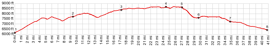
1.(00.0m,6140ft)START-END EAST-1: low point on Ut44 at the jct with an access rd to Flamging Gorge Reservoir
2.(09.4m,7700ft)route turns west onto FR539
3.(17.3m,8380ft)jct with one way climb to Ute Mtn lookout
4.(24.5m,8700ft)TOP: profile takes turnoff to Long Park Reservoir on right
5.(27.1m,8600ft)path has crossed reservoir dam and starts descend down Sheep Creek Canyon
6.(29.7m,7600ft)profile turns right onto D1 rd
7.(34.9m,7230ft)route joins Ut43, west of Manila
8.(40.8m,6410ft)START-END EAST-2: jct Ut43 - Ut44 in Manila
|