| |
| |
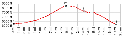
Sheep Creek Canyon s(u)
This road is perfect for a bicycling
geologist - although such a person may have a hard
time, deciding weather to keep going or stop to
examine the rocks. Actually, by most people's
standards, this is a great ride - what little
traffic there is, is slow and there for the rocks,
not to get anywhere. The road is still fairly
wide, but it has a more intimate character than
your typical US highway. All the above applies to
the Sheep Creek Canyon approach on the left side
of the profile. The other side is a typical US
highway, but with views, that reach farther to the
horizon.
At the turnoff the Sheep Creek Canyon road gives
the impression of being heavily graveled. But
there is a hard surface underneath and the gravel
is present only on short stretches near the
bottom. The road stays next to Sheep Creek,
splashing through the bushes next to the road. In
the next miles it crosses a picture book of
geologic formations, starting with the Moenkopi
formation and ending with the precambrian Uinta
Group. All formations are labeled with road side
signs, though sometimes they transition so quickly
that you don't know which formation the sign
points to.
From South. (described
downwards). Looking back you can catch the only
glimpse of the gentle snow covered Uinta Crest on
this ride. A quick roll leads through an open
meadow.backed by a gentle variety of Uinta slopes.
Before the jct with Ut44, a sign illustrates the
geologic history of the Uinta Mountains, from
stress fractures to rift valley, later filled in
with sediments to mountain building episodes
contemporaneous with the Rocky Mountains. The
mountains have been stable for the 60 million
years - hence their rounded appearance. The profile goes left back down to the low point
on Sheep Creek, passing a real life picture, of
what could pass as an advertisement image for
Flaming Gorge, and also a nice far view of lower
Sheep Creek Canyon. 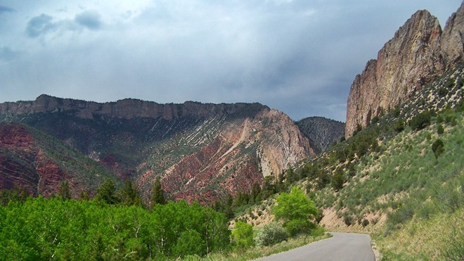
|
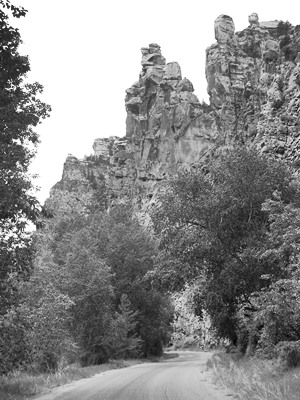 Two switchbacks
lead the road out of the canyon and confront the
cycling geologist with a picture perfect picture
of a monocline along the Uinta fault. The rock
layer goes from horizontal to a deep dive into the
ground. This is the last of the great rock
scences. The road exits the Sheep Creek Geologic
area and climbs steeply, surrounded by open
forest. The straight away across the top contains
three spots eligible for being possibly the
highest point. I think it is the first one,
immediately before the jct with FR221.
Two switchbacks
lead the road out of the canyon and confront the
cycling geologist with a picture perfect picture
of a monocline along the Uinta fault. The rock
layer goes from horizontal to a deep dive into the
ground. This is the last of the great rock
scences. The road exits the Sheep Creek Geologic
area and climbs steeply, surrounded by open
forest. The straight away across the top contains
three spots eligible for being possibly the
highest point. I think it is the first one,
immediately before the jct with FR221.|
|
advertisement |
|
|
advertisement |